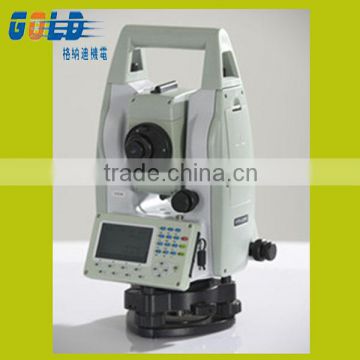
Laser Reflectorness Total Station With Good Quality
US$ 0.1 - 0.2
/ Set
1 Set(Min. Order)
- Chongqing
- T/T Credit Card
You May Like
-
 Topcon GETAC PS236 Handheld Feild Data Controller
-
HI TARGET V60 GPS RTK RECEIVER GNSS REVEIVER PRICE
-
GNSS RTK SYSTEM HI TARGET V60 GPS RTK RECEIVER GEOLOGICAL SURVEY INSTRUMENT
-
HI TARGET V60 GPS RECEIVER GNSS RTK HIGHACCURACY GPS RECIEVER CHEAP FOR SALE
-
HITARGET V60 GPS GNSS RTK SURVEYING AND MAPPING INSTRUMENT
-
GNSS RECEIVER MODULE GPS RECEIVER RTK SYSTEM HI TARGET V60 GPS SURVEY EQUIPMENT
Product Details
| Place of Origin | China | Brand Name | HI-TARGET Reflectorness Total Station | |
| Model Number | HTS-220R reflectorness total station |
Product Description
Laser reflectorness total station with good quality
*Detail data of the Reflectorness Total Station:
Angle Measurement
Measurement Method: Absolute Encoding
Minimum Readout: 1″/5″/10″(0.3mgon/1.5mgon/3mgon)adjustable
Accuracy1 : 2”
Distance Measurement (HTS-220 with Reflector)
Single Prism: 3000m (9,842ft.) under good condition3
Three Prisms: 6000m (19,685ft.) under good condition3
Reflective Sheet: 800m (2,624 ft.)
Accuracy: 2 mm +2ppm
Measuring Time (Fine/Quick/Tracking): 1.5s/1s/ 0.5s
Distance Measurement (HTS-220R Reflectorless)
Reflectorless2 Range: 350m (1,148 ft.)
Single Prism: >7500m (24,606ft.)
Accuracy: 3mm+2ppm
Measuring Time: 1.5s
Telescope
Magnification: 30X
Field of View: 1°30′ (2.7m at 100m)
Minimum Focusing Distance: 1.5m
Reticle: Illuminated
Compensator
System: Single-axis liquid tilt sensor/Dual-axis (optional)
Working Range: ±3′
Setting Accuracy: 1″
Communication
Bluetooth
Interface: Standard RS232, SD card4, USB pen drive, mini-B
Internal Data Memory: Approx. 20,000 Points
Data Format: ASCII
Operation
Operation system: Real-time Operating System
Display: High resolution backlight black and white display with contrast adjustment/ Graphics: 280 x 160 pixels / Character: 6 lines x 25 characters
Keyboard: 2 sides Alphanumeric backlit crystal keyboard
Laser Plummet
Type: Laser point, 4 brightness levels adjustment / Optical plummet (optional)
Centering Accuracy: 1 mm at 1.5m instrument height
Power Supply
Battery Type: Rechargeable Li-ion battery
Voltage/Capacity: ZBA-400: 7.4V (DC) / 3000mAh
Operating Time With ZBA-400: Optimal 16 hours5 (Continuous angle measurement every 30 seconds) / 10 hours (typical)
Measuring Times: Approx. 12000 times
Weight
Weight (Incl. Battery&Tribrach): Approx. 5.5kg (12.1lb.)
Environmental
Operating Temperature: -20℃ ~+50℃ ( -4℉ to +122℉)
Storage Temperature: -40℃ ~+70℃ (-40℉to +158℉)
Dust&Water Proof (IEC60529 Standard)/Humidity: IP65, 95%, non-condensing
Contact US
Contact Us
- Chongqing Huobo Surveying Instruments Co., Ltd.
- Contact nameMichelle Li Chat Now
- Phone0086-023-62794421
- AddressNo. 7-8, No. 23, Nanping West Road, Nanping Street
Product Categories
| Drilling Rig | Mapping GIS | New Products | Surveying |
New Products
-
Hi Target H32 GPS, V30 Gps, V60 Gps ,V90plus Gps Rtk Topographic Equipment For Sale
-
Hi Target V60 GPS RTK Trimble OEM Surveying Equipment for Sell
-
HI-TARGET Dual Frequency Cheap and Fine RTK GPS for Engineering Survey
-
High Precision Multi-satellites Signal GPS Receiver With CE,FC Certification
-
Land Survey Project Coordinate Measuring GNSS RTK GPS
-
Hot Sale 2015 New Condition Total Station With High Accuracy
-
Engineering Construction Survey Equipment Total Station for Multi-function
-
RTK GPS GNSS RECEIVER Hi Target V60 GNSS RTK Centimeter-Level Positioning High Accuracy Surveying Instrument
-
Centimeter-Level Positioning High Accuracy RTK GPS GNSS RECEIVER Hi Target V60 GNSS RTK for Land Surveying
-
Centimeter-Level Positioning High Accuracy Differential GPS Receiver Hi Target V60 GNSS RTK for Land Surveying
-
Centimeter-Level Positioning High Accuracy GPS Receiver for Land Surveying
-
Hi Target DGPS Reference Receivers GPS RTK System for Geol Survey
-
Chinese Factory Provide HTS-220R Total Station
-
Cheap and Fine Chinese HI-TARGET Total Station With CE,FC Certification
-
Chinese High Accuracy Total Station
-
Large Data Storage With 8GB Internal Micro SD Hi-Target V60 GPS GLONSS RTK Survey
-
Dual Frequency GPS GNSS Base or Rover RTK Land Survey
-
Latest Navigation System Products of GPS GNSS Made in China
-
Hi-Target GPS GLONSS Survey Gps Equipment for Topographic Surveys
-
Rinex Storage and Quick Upgrade V60 GNSS GPS RTK Surveying System
-
Construction Mapping GNSS GPS RTK System or Static Surveying
-
V30 GNSS GPS GLONSS BDS Base or Rover RTK Survey Instruments
-
Series of Hi-Target GNSS GPS RTK Survey Instruments for Wholesale and Retail
-
V60 Hi-Target Multi- Receiver GNSS GPS GLONSS BDS for Cheap Sale
Popular Searches
- lens meter
- optical mirror
- auto refractometer rm-9000
- solar energy fresnel lens
- bk7 optical glass blank
- acrylic google cardboard biconvex lens
- laser mirror
- topcon robotic total station
- topcon total station gts
- trimble robotic total station
- large plastic fresnel lens
- parabolic mirror
- trimble m3 total station
- cylindrical achromat
- pentax total station
- small lens
- combined table ophthalmic unit
- automatic lens edger
- hand lens edger
- manual lens edger
- ophthalmic motorized table
- auto lens groover
- auto lens meter
- lcd vision chart
- angel eyes projector lens
- fly eye lens
- dielectric mirror
- usb lens
- topcon reflectorless total station
- laser reflection mirror
Recommended Products
- Optometer Illuminometer LX-1261R
- Window Tint Meter DB22-TM273/OEM/ODM
- Light Transmittance Meter DB22-TM275/DB22-TM275P/DB22-TM275P6
- 3104 Remote Particle Counter for Online Clean Room Monitoring System
- UV IRRADIANCE METER DB22-UVseries
- Rod Lens Borosilicate Glass Rod
- Scanning Galvanometers (silicon Material)
- G5 Series Articulating Videoscope Borescope,HD Industrial Videoscope
- 2/4/6/8 Inch Semiconductor N Type Silicon Wafer
- Ar Coating Bk7 15mm Plano Concave Cylindrical Lens for Imaging
- Ar Coating Bk7 Dome Glass Lens for Underwater Protection
- Four Dimensional Reflective Beam Splitter Frame, Disc Spring Lens Holder, Tilt Adjustable Seat for Two-dimensional Translation and Tilt of the Lens
Find Similar Products By Category
- Instruments & Meters > Optical Lens & Instrument > Optical Lens
- Please Enter your Email Address
- Please enter the content for your inquiry.
We will find the most reliable suppliers for you according to your description.
Send Now
Chongqing Huobo Surveying Instruments Co., Ltd.
AIBot OnlineThis conversation is AI-generated. Contact manufacturer before transaction to confirm info.
-
 Michelle Li
Hi there! Welcome to my shop. Let me know if you have any questions.
Michelle Li
Hi there! Welcome to my shop. Let me know if you have any questions.
Your message has exceeded the limit.
- Contact supplier for lowest price
- Customized Request
- Request Sample
- Request Free Catalogs
Your message has exceeded the limit.
-
Purchase Quantity
-
*Sourcing Details
Your inquiry content must be between 10 to 5000 characters.
-
*Email
Please enter Your valid email address.
-
Mobile