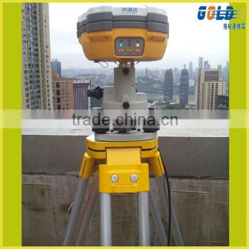
Land Survey RTK GPS,GNSS RTK GPS From Chinese Market Survey Equipment
USD $1 - $15,000
/ Set
1 Set(Min.Order)
- Chongiqng port
- T/T Credit Card

You May Like
-
 Engineering construction survey RTK GPS HI-TARGET Land Survey Equipment
-
GeoMax Zipp20 Total Station
-
High Precision HI-TARGET Brand GPS Base and Rover for land Surveying
-
High Accuracy Engineering and Geodetic Survey Total Station
-
HI-TARGET V90Plus GPS Base and Rover GPS Positioning
-
GPS GNSS Rover Base Hi target GNSS RTK receiver and Geodetic GPS Receiver for Environment Studies
Product Details
| Place of Origin | China | Brand Name | HI-TARGET RTK GPS Survey Equipment | |
| Model Number | V30 RTK GPS Survey Equipment |
Product Description
Land Survey RTK GPS,GNSS RTK GPS From Chinese Market Survey Equipment
The V30 GNSS RTK system is designed to meet high quality standards at an affordable price. It is outstanding in its class, with a rugged design and user-friendly functions.
*The main features of the V30 RTK GPS Survey Equipment:
Multi-constellation tracking
- 220 tracking channels.
- Supports GPS, GLONASS, GALILEO, BDS, SBAS.
- NGS approved GNSS antenna.
- Intelligent operation
- Equipped with a smart speaker guiding the whole operation.
- Multi one-button functions make fieldwork easier, such as auto base setup by one button, the rover can get fix solution once it is turned on.
Diversify RTK application
- Optional transceiver UHF radio
- The transceiver UHF radio enables the working mode to be switchable between base and rover.
- 2-watt HI-TARGET internal UHF radio and 2-watt Pacific Crest TrimTalk© internal UHF radio are optional. Pacific Crest TrimTalk© internal UHF radio is compatible with other radios.
Removable internal UHF radio enables users to fix or exchange simply. - Seamless operation in CORS system
- Built-in GPRS/GSM/3G module ensures that the V30 works perfectly with network RTK positioning.
Long-life battery
- Powered by 5000mAh Li-ion battery.
- Static working time 13 - 15 hours.
- RTK Rover (UHF/GPRS/GSM) working time 10 - 12 hours.
- RTK Base working time 8 - 10 hours.
Rugged and unique design
- IP67 dust/water protection.
- Withstands 3-meter natural fall onto concrete.
- Rapid tracking and perfect avoidance or reduction of obstruction and multipath effect to ensure superior positioning capability.
*Specification of the V30 RTK GPS Survey Equipment:
- 220 Channels
- Advanced Pacific Crest Maxwell 6 Custom Survey GNSS Technology
- High precision multiple correlator for GNSS pseudo range measurements
- Unfiltered, unsmoothed pseudo range measurements data for low noise, low multipath error, low time domain correlation and high dynamic response
- Very low noise GNSS carrier phase measurements with <1 mm precision in a 1 Hz bandwidth
- Signal-to-Noise ratios reported in dB-Hz
- Proven Pacific Crest low elevation tracking technology
*Satellite signals tracked simultaneously
GPS: Simultaneous L1C/A, L2C, L2E, L5
GLONASS: Simultaneous L1C/A, L1P, L2C/A (GLONASS M only), L2P
SBAS: Simultaneous L1 C/A, L5
Galileo: Simultaneous L1 BOC, E5A, E5B, E5AltBOC
BDS: B1, B2
QZSS: L1 C/A, L1 SAIF, L2C, L5
*Positioning Performance of the GPS base and rover
Static and Fast Static GNSS surveying
Horizontal: 2.5mm+0.5ppm RMS
Vertical: 5mm+0.5ppm RMS
Post Processing Kinematic
(PPK / Stop & Go) GNSS surveying
Horizontal: 1cm+1ppm RMS
Vertical: 2.5cm+1ppm RMS
Initialization time: typically 10 minutes for base while 5 minutes for rover
Initialization reliability: typically > 99.9%
RealtimeKinematic(RTK) surveying
Horizontal: 8mm+1ppm RMS
Vertical: 15mm+1ppm RMS
Initialization time: typically < 8 seconds
Initialization reliability: typically > 99.9%
Code Differential GNSS positioning
Horizontal: 25cm+1ppm RMS
Vertical: 50cm+1ppm RMS
SBAS[iv]: 0.50m Horizontal, 0.85m Vertical
*Hardware
Physical
Dimensions (W x H): 19.50cm x 10.40cm(7.68 in x 4.09 in)
Weight: 1.3kg (2.86lb) with internal battery, internal radio, standard UHF antenna
Operating temperature: -45℃to +65℃ (-49℉ to +149℉)
Storage temperature: -55℃ to +85℃ (-67℉ to +185℉)
Humidity: 100%, considering
Water/dustproof: IP67 dustproof, protected from temporary immersion to depth of 1m (3.28ft).
Shock and Vibration: Designed to survive a 3m(9.84ft) natural fall onto concrete.
Electrical
Power 6V to 28V DC external power input
Power consumption 2.5W
Automatic Switching between internal power and external power
Rechargeable, removable 7.4V, 5000mAh Lithium-Ion battery in internal battery compartment
Internal battery life
Static 13 - 15 hours
RTK Rover (UHF/GPRS/3G) 10 - 12 hours
RTK Base 8 - 10 hours
I/O interface
1 x Bluetooth
1 x standard USB2.0 port
2 x RS232 serial port
2 x DC power input (8-pin & 5-pin)
*Communication and Data storage
GPRS/GSM or 3G
Fully integrated, fully sealed internal GPRS/GSM or 3G
Network RTK (via CORS) range20-50km
HI-TARGET internal UHF radio (standard)
Transmitting Power: 0.1W, 1W, 2W adjustable
Transmitting Speed: Up to 19.2Kbps
Working Range: 3~5Km typical, 8~10km optimal
Pacific Crest XDL micro Internal UHF Radio
Frequency: 403~473 MHz
Transmitting Power: 0.5W, 1.0W, 2.0W adjustable
Transmitting Speed: Up to 19.2Kbps
Support most of radio communication protocol
Working Range: 3~5km typical, 8~10km optimal
HI-TARGET External UHF radio (standard)
Frequency: 460 MHz with 116 channels
Transmitting Power: 5W, 10W, 20W, 30W adjustable
Transmitting Speed: Up to 19.2Kbps
Working Range: 8~10Km typical, 15~20km optimal
Pacific Crest ADL Vantage Pro External UHF radio
Frequency: 390~430 MHz or 430~470 MHz
Transmitting Power: 4W to 35W adjustable
Transmitting Speed: Up to 19.2Kbps
Support most of radio communication protocol
Working Range: 8~10Km typical, 15~20km optimal
Support other external communication device
For example, external GSM modem.
Data storage
64MB internal memory
Data formats
(1Hz positioning output, up to 50 Hz - depends on installed option)
CMR: sCMRx, CMR, CMR+input and output
RTCM: RTCM 2.1, 2.2, 2.3, 3.0, 3.1 input and output
Navigation outputs ASCII: NMEA-0183 GSV, AVR, RMC, HDT, VGK, VHD, ROT, GGK, GGA, GSA, ZDA, VTG, GST, PJT, PJK, BPQ, GLL, GRS, GBS
Navigation outputs Binary: GSOF
1 Pulse Per Second Output
Contact US
Contact Us
- Chongqing Huobo Surveying Instruments Co., Ltd.
- Contact nameMichelle Li Chat Now
- Phone0086-023-62794421
- AddressNo. 7-8, No. 23, Nanping West Road, Nanping Street
Product Categories
| Drilling Rig | Mapping GIS | New Products | Surveying |
New Products
-
Hi target GPS Glonass V60 RTK System RTK GNSS Price Topographic equipment for sale
-
Geodetic GPS Receiver and GPS GNSS Rover Base Hi target GNSS RTK receiver
-
Geographic Surveying and Mapping Instrument Hi target RTK GPS Base and Rover
-
Hydrographic and Topographic surveying with Hi target GPS RTK Receiver by Bluetooth or NFC wireless Connection
-
Hi target Global Positioning Systems with High Positioning Accuracy GNSS Receiver for Hydrographic and Mining
-
Seamlessly Operation in VRS System Hi Target Landing Surveying GPS RTK Reveiver for sale
-
Hi Target GPS Receiver GLONSS Receiver Modern Survey Instruments GPS for Land Survey
-
HI TARGET PACIFIC CREST GNSS POSITIONING TECHNOLOGY GPS RTK LI L2 Topographic Equipment For Sale
-
Hi target GPS Receiver h32 , V30, V60 for land Static Survey and RTK Survey
-
Dual Frequency High Precision GNSS RTK Topographic Surveying And Mapping System
-
Professional Topographic Surveying GNSS RTK Base And Rover System
-
Multi-constellation Signal Tracking GNSS RTK Survey System GPS Surveying System
-
Full Satellites Signal Receiving High Accuracy GNSS RTK System GPS Receiver
-
Full Constellation Signal Tracking Topographic GNSS RTK Survey System
-
High Precision Professional Topographic Survey GNSS RTK System
-
Sub-centimeter Precision RTK Surveying Base And Rover GNSS RTK System
-
Control Coordination Surveying GPS Receiver GNSS RTK Survey System
-
Compact Dual-frequency Land Surveying GNSS RTK System For Land Surveying
-
Topographic Surveying High Accuracy Compact GNSS RTK System
-
Civil surveying instrument GPS base and rover
-
Most Flexible GNSS System RTK GPS WIFI,Bluetooth,USB connected
-
Widely use easy operation land survey GPS with RTK mode
-
H32 GNSS RTK System,High Precision RTK GPS,Civil Surveying GPS
-
Hi Target VNet 9 GPS Receiver CORS RTK for Deep Foundation and other high-precision deformation monitoring
Popular Searches
- digital tester
- Resistance Tester
- electrical instrument
- test instrument
- lab equipment
- analysis instrument
- laboratory instrument
- Asphalt Mixture Mixer
- launch x431 master
- x431
- Gloss Meter
- Resistance Meter
- digital instrument
- dc load bank
- testing equipment
- testing machine
- battery load bank
- Circuit Tester
- Impact Tester
- lab instrument
- weather station
- gps receiver
- laboratory instruments
- test equipment
- laboratory equipment
- electronic timer
- electronic meter
- electronic instrument
- Electricity Meter
- data collector
Recommended Products
- Handheld ultrasonic concrete crack scanner Ultrasonic testing for hidden cracks in concrete Real-time concrete crack monitoring system
- Automated crack mapping with UPV Best ultrasonic crack detector for concrete Price of portable UPV crack measurement tool
- Time-of-flight (TOF) crack depth measurement Surface wave testing for crack detection Digital ultrasonic concrete testing device
- Tunnel & dam crack inspection with UPV Building structural crack assessment tool Ultrasonic pulse echo for concrete cracks
- Bridge inspection ultrasonic crack detector Concrete slab crack measurement equipment Highway pavement crack depth analyzer
- Portable ultrasonic concrete crack gauge Non-destructive ultrasonic crack depth tester Concrete crack width and depth measurement tool
- Ultrasonic concrete crack depth meter Ultrasonic pulse velocity (UPV) crack detector NDT ultrasonic crack measurement device for concrete
- Handheld device for measuring surface cracks Automated crack detection system for quality control Real-time crack monitoring equipment
- High-precision ultrasonic crack detector price Compare crack width measurement systems NDT crack detection equipment suppliers
- 3D scanning for crack depth analysis Best crack depth measurement device for industrial use Affordable portable crack inspection tool
- Time-of-flight diffraction (TOFD) crack measurement Laser-based crack width measurement Digital microscope for crack analysis
- Metal fatigue crack testing device Railway track crack inspection equipment Phased array ultrasonic testing (PAUT) for cracks
Find Similar Products By Category
- Instruments & Meters > Test Instrument > Test Machine
- Please Enter your Email Address
- Please enter the content for your inquiry.
We will find the most reliable suppliers for you according to your description.
Send Now
Chongqing Huobo Surveying Instruments Co., Ltd.
AIBot OnlineThis conversation is AI-generated. Contact manufacturer before transaction to confirm info.
-
 Michelle Li
Hi there! Welcome to my shop. Let me know if you have any questions.
Michelle Li
Hi there! Welcome to my shop. Let me know if you have any questions.
Your message has exceeded the limit.
- Contact supplier for lowest price
- Customized Request
- Request Sample
- Request Free Catalogs
Your message has exceeded the limit.
-
Purchase Quantity
-
*Sourcing Details
Your inquiry content must be between 10 to 5000 characters.
-
*Email
Please enter Your valid email address.
-
Mobile