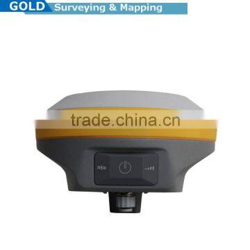
Sub-centimeter Precision RTK Surveying Base And Rover GNSS RTK System
- 100 Set / Sets per Month
- Chongqing China
- T/T

You May Like
-
 Control Coordination Surveying GPS Receiver GNSS RTK Survey System
-
Compact Dual-frequency Land Surveying GNSS RTK System For Land Surveying
-
Topographic Surveying High Accuracy Compact GNSS RTK System
-
Civil surveying instrument GPS base and rover
-
Most Flexible GNSS System RTK GPS WIFI,Bluetooth,USB connected
-
Widely use easy operation land survey GPS with RTK mode
Product Details
| Type | Gps Receiver | Use | Automotive | |
| Screen Size | Other | Function | Bluetooth-enabled | |
| Place of Origin | Chongqing, China | Brand Name | Hi-target | |
| Model Number | V90 plus | Warranty | 1 Years |
Product Description
Sub-centimeter Precision RTK Surveying Base And Rover GNSS RTK System
Small and lightweight
·Only weighs 950g.
·Measures Diameter 153mm x Height 83mm.
Multi-constellation Tracking
·220 tracking channels
·Supports GPS, GLONASS, GALILEO, BDS, SBAS
·NGS approved full-band GNSS antenna
Smart Application
·Offers tilt survey with a maximum tilt angle of 30 degrees.
·Supports electronic bubble calibration
·The internal NFC module makes Bluetooth communication quick and easy.
·Intelligent voice assistance guides field operations. Voice can be DIY.
·Standard Rinex data and HI-TARGET raw data recorded simultaneously.
Optional Transceiver UHF Radio
·The transceiver UHF radio enables switchable working modes between base and rover.
·Three types of internal UHF radio provide different frequencies based on users requirements. The Pacific Crest TrimTalk© internal UHF radio is compatible with other radios.
Multi-network Connection
·Supports GPRS, GSM and WCDMA
·Supports WIFI
Powerful Battery
·Powered by high-capacity (5000mAh) Li-ion battery to ensure full day operation
Rugged Design
·IP67 dustproof and waterproof
·Able to survive a 3-meter natural fall onto concrete
Satellite Signals Tracked Simultaneously
220 Channels
GPS……….. Simultaneous L1C/A, L2C, L2E, L5
GLONASS……………..Simultaneous L1C/A, L1P, L2C/A (GLONASS M only), L2P
SBAS……………………. Simultaneous L1 C/A, L5
Galileo………………... Simultaneous L1 BOC, E5A, E5B, E5AltBOC
BDS………………..…….……………………………. B1, B2
QZSS…………………….. L1 C/A, L1 SAIF, L2C, L5
POSITIONING PERFORMANCE
Static and Fast Static GNSS Surveying
Horizontal……………………2.5mm+0.5ppm RMS
Vertical…………………………. 5mm+0.5ppm RMS
Post Processing Kinematic (PPK / Stop & Go) GNSS Surveying
Horizontal……………………….. 1cm+1ppm RMS
Vertical………………………… 2.5cm+1ppm RMS
Initialization time……….Typically 10 minutes for base while 5 minutes for rover
Initialization reliability……Typically > 99.9%
Real Time Kinematic (RTK) Surveying
Single Baseline
Horizontal……………………….. 8mm+1ppm RMS
Vertical…………………………. 15mm+1ppm RMS
Network RTK
Horizontal……………………….. 8mm+0.5ppm RMS
Vertical………………………….. 15mm+0.5ppm RMS
Initialization time……..…Typically < 8seconds
Initialization reliability…….Typically > 99.9%
Code Differential GNSS Positioning
Horizontal………………………. 25cm+1ppm RMS
Vertical…………………………… 50cm+1ppm RMS
SBAS ……… 0.50m Horizontal, 0.85m Vertical
HARDWARE
Physical
Dimensions (W x H)…….153mm x 83mm (6.02inch x 3.27inch)
Weight………950g (2.09lb) without internal battery
Operating temperature………. -40℃to +65℃ (-40℉ to +149℉)
Storage temperature…………. -40℃ to +75℃(-40℉ to +167℉)
Humidity………………………. 100%, considering
Water/dustproof……………….. IP67 dustproof, protected from temporary immersion to depth of 1m (3.28ft).
Shock and vibration……………Designed to survive a 3m(9.84ft) natural fall onto concrete.
Electrical
Power 6V to 28V DC external power input
Power consumption ≤3.5W
Automatic switching between internal power and external power
Rechargeable, removable 7.4V, 5000mAh Lithium-ion battery in internal battery compartment
Internal Battery Life
Static 12hours
RTK rover (UHF/GPRS/3G) 8-10 hours
RTK base 8 hours
I/O Interface
1 xBluetooth, NFC
1 x standard USB2.0 port
1 x TNC antenna connector
1 x RS232 serial port
1 x DC power input (5-pin)
Tilt Survey System
Electronic Bubble
COMMUNICATION
Network Communication
Fully integrated, fully sealed internal WCDMA, compatible with GPRS, GSM
Wifi frequency is 2.4G, supports 802.11b/g/n protocol
Network RTK (via CORS) range20-50km
HI-TARGET Internal UHF Radio(Standard)
Frequency… 450~470MHz with 116 channels
Transmitting power…0.5W, 1W, 2W adjustable
Transmitting speed……….9.6Kbps, 19.2Kbps
Working range………….3~5km typical, 8~10kmoptimal
Pacific Crest XDL Micro Internal UHF Radio
Frequency…………………………….403~473MHz
Transmitting power……………… 0.5W, 2W adjustable
Transmitting speed…………….. Up to 19.2Kbps
Support most of radio communication protocol
Working range……………………… 3~5km typical, 8~10km optimal
HI-TARGET External UHF Radio (Standard)
Frequency………… 460MHz with 116 channels
Transmitting power……. 5W, 10W, 20W, 30W adjustable
Transmitting speed…………… Up to 19.2Kbps
Working range…………………. 8~10km typical, 15~20km optimal
Pacific Crest ADL Vantage Pro External UHF Radio
Frequency…. 390~430MHz or 430~470MHz
Transmitting power….. 4W to 35W adjustable
Transmitting speed…………….. Up to 19.2Kbps
Support most of radio communication protocol
Working range…. 8~10km typical, 15~20km optimal
SYSTEM CONFIGURATION
System
Data storage…………………16GB Internal storage (Support up to 32GB external SD card)
Record GNS and RINEX format simultaneously
Data Formats
1Hz positioning output, up to 20Hz
CMR: CMR, CMR+, sCMRx input and output
RTCM: RTCM 2.1, 2.3, 3.0, 3.1, 3.2 input and output
Navigation outputs ASCII: NMEA-0183 GSV, AVR, RMC, HDT, VGK, VHD, ROT, GGK, GGA, GSA, ZDA, VTG, GST, PJT, PJK, BPQ, GLL, GRS, GBS
Navigation outputs binary: GSOF
Any question, please feel free to contact:
Contact Us
- Chongqing Huobo Surveying Instruments Co., Ltd.
- Contact nameMichelle Li Chat Now
- Phone0086-023-62794421
- AddressNo. 7-8, No. 23, Nanping West Road, Nanping Street
Product Categories
| Drilling Rig | Mapping GIS | New Products | Surveying |
New Products
-
H32 GNSS RTK System,High Precision RTK GPS,Civil Surveying GPS
-
Hi Target VNet 9 GPS Receiver CORS RTK for Deep Foundation and other high-precision deformation monitoring
-
Hi Target VNet 9 GPS Receiver CORS RTK for Landslide monitoring and early warning
-
Hi-target VNet 9 Receiver GNSS GPS GLONSS cors rtk receiver
-
New Hi Target VNet 9 GPS Reciver for CORS RTK Base System gnss reference station
-
HI-TARGET's Sophisticated GPS/GNSS technology Providing quality CORS construction
-
Hi Target VNet 9 Hi Accuracy GPS RTK CORS RTK for Precision Agriculture
-
Hi Target VNet 9 GPS VRS system base Station for Surveying and mapping
-
Hi Target VNet 9 Dual Frequency Survey GNSS
-
Hi Target VNet9 GNSS GPS CORS Receiver Station for landslides monitoring
-
High Accuracy,Productivity and Efficiency. Hi-target VNet 9 Differential GPS Base Station
-
Hi Target VNet9 GNSS Continuously Operating Reference Station
-
Hi Target VNet 9 GNSS Base Station for CORS/VRS system and monitoring system
-
Hi-target VNet 9 GPS GLONSS BDS Base Station GPS
-
Hi Target Gnss Reference Station VRS system VNet 9 CORS RTK
-
Hi Target Hydrographic Survey DGPS Device RTK GNSS Reciver
-
Professional Geographical Information Systems Tool Hi target China Brand GPS RTK Base and Rover
-
Engineering Mapping Survey Tool Cheap sale hi target GNSS GPS GLONSS receiver
-
Surveying and Construction GNSS GPS RTK System
-
Hot sale HI-TARGET H32 GNSS RTK GPS at Best Price/GPS Base and Rover
-
HI-Target RTK Mode High Accuracy GPS Receiver Signal Receiver
-
Hi TARGET V30 GPS RTK SYSTEM Trimble GPS Motherboard BD970 Landing survey
-
Hi TARGET CLASSICS GNSS RECEIVER V30 RTK GPS RECEIVER H32 RTK GNSS RECEIVER
-
pipeline mapping, highway and railway mapping, topographical mapping, hi-target V90 plus GNSS Reveiver mapping instrument rtk
Popular Searches
- satellite
- gsm
- gps navigator
- gps navigation box
- gps chipset
- car gps
- box gps car navigation
- vehicle device
- call logger
- gps tracker
- car tracker
- Gps Car Alarm
- Tracking Car Alarm
- gps navigation
- car navigation
- gps navigation system
- Car Gps Tracker
- Gps Tracking System
- Gps Vehicle Tracking System
- Gps Map
- mini antenna satellite
- sim card backup
- car gps navigation
- Navigation & GPS
- gps system
- navigator
- gps device
- portable gps
- Car Navigation Gps
- Tracker Gps
Recommended Products
- Original SMC IP200-120 cylinder positioner New original authentic
- Hi Target GPS V200 GNSS RTK Receiver with tilt sensor
- Hi Target GPS V200 GNSS RTK Receiver with tilt sensor
- 4 Channel HD Mobile DVR 1080P Public Bus Truck Mdvr GPS 3G 4G Mobile DVR
- Full HD HDD 8CH 1080P DVR para vigilancia por vídeo de seguran?a de veículos
- 107M Series (Type A, Type B, Type C, Type D) Double Antenna Combination Micro Inertial Measurement System
- 105M Series (Type A, Type B, Type C, Type D) Single Antenna Combination Micro Inertial Measurement System
- INS1200 Series Fiber Optic GNSS/INS Integrated Inertial Navigation System of Type A, Type B, Type C, and Type D
- INS900 Series Fiber Optic GNSS/INS Integrated Inertial Navigation System of Type A, Type B, Type C, and Type D
- INS600 Series Fiber Optic GNSS/INS Integrated Inertial Navigation System of Type A, Type B, Type C, and Type D
- INS300 Series Fiber Optic GNSS/INS Integrated Inertial Navigation System of Type A, Type B, Type C, and Type D
- FOG900 Series A-type, B-type, C-type, D-type Fiber Optic Gyroscope
Find Similar Products By Category
- Electrical & Electronics > GPS > GPS Navigator
- Please Enter your Email Address
- Please enter the content for your inquiry.
We will find the most reliable suppliers for you according to your description.
Send Now-
 Michelle Li
Welcome to my shop, I'm glad to serve you. Please feel free to send me any questions you may have.
Michelle Li
Welcome to my shop, I'm glad to serve you. Please feel free to send me any questions you may have.
Your message has exceeded the limit.
- Contact supplier for lowest price
- Customized Request
- Request Sample
- Request Free Catalogs
Your message has exceeded the limit.
-
Purchase Quantity
-
*Sourcing Details
Your inquiry content must be between 10 to 5000 characters.
-
*Email
Please enter Your valid email address.
-
Mobile