Home > Products > 3D laser radar surveying & map system > 3D Imaging Laser Radar Surveying and Mapping System
3D Imaging Laser Radar Surveying and Mapping System
- Shenzhen China

You May Like
-
 3D LIDAR and Mapping System
-
active noise cancelling headphones,military class
-
active noise cancelling headphones,Astronauts use class
-
active noise cancelling earphone,Astronauts use class
-
active noise cancelling protective earmuff, Alternative international brand no 1, water proof
-
active noise cancelling protective earmuff,Astronauts use class, water proof
Product Description
Introduction
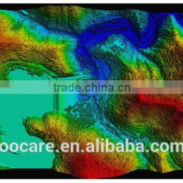
This product is a three-dimensional laser radar surveying and mapping system, LIDAR for short, which is now the most advanced and highly precision three-dimensional surveying and mapping device all over the world. It uses the practical sub-miniature aircraft radar, integrates the laser scanner, global positioning system (GPS), inertia measurement system and fast measurement system of INS, obtains the spatial three-dimensional coordinate information of the target through the distance measurement by directly launching the laser pulse to the target, assembles the digital camera and obtains the target image at the same time to rapidly and accurately obtain the three-dimensional information about the real world.
This system has the characteristics of high degree of automation, less weather impacts, short cycle of data production, high precision and so on, thus it is the only practical sub-miniature aircraft radar all over the world.
Characteristic:
High Precision
The data precision is the soul of the instrument of surveying and mapping. The LIDAR uses surveying and mapping integrating three major systems, greatly reducing the data error and dead view zone and its captured ground data error will be no greater than 0.2m, which is equivalent to distinguishing on the plane which leg the pedestrian on the ground strides out. Such precision is sufficient to meet any military and civilian surveying and mapping requirement.
Light Weight
At present, the weight of the overseas instruments of surveying and mapping of the same kind is often over 100kg, and with the volume being equivalent to that of the domestic refrigerator, while the weight of our LIDAR is no more than 10kg, its volume is equivalent to that of a microwave oven and its operating time can reach 24h. Its durability and flexibility reach the leading level at home and abroad.
Low Cost
At present, most surveying and mapping products of the same kind can be only carried on the manned aerial vehicles for surveying and mapping, while our LIDAR can be carried by various aircrafts such as unmanned aerial vehicle, airship, powered hang glider, helicopter and so on and at the same time, the standard airport is not a must for the takeoff site. The flat ground with the length of 200m and width of 16m can be used for lifting and landing, greatly reducing the flight cost for surveying and mapping.
Parameter:
Weight ≤10KG
Working time 24h
Absolute surveying and mapping precision <0.2M
Takeoff site Width ≥16m and length ≥200m
Drawing data type DTM, DEM, DOM, DLG and contour map
Application field:
In terms of military application: it can be widely applied to the military surveying and mapping, frontier landform reconnaissance at war, submarine terrain reconnaissance, mine detection and evadible system of the helicopter and so on and can provide the spatial data results with high precision and large scale (from 1:500 to 1:10000).
In terms of the civilian application: it can be widely applied to the fields such as three-dimensional electric power line patrol system of the State Grid, route selection for electric power circuit optimization, hydraulic engineering survey, forest surveying and mapping, land ownership surveying and mapping, three-dimensional expressway management system and so on.
Case
1. Hydraulic engineering survey, explore, monitor and maintain the hydraulic engineering etc. and the surveying and mapping precision comprehensively surpasses that of surveying and mapping of the traditional aerial photo.
2. Forest surveying and mapping, conduct surveying and mapping for the park landform, forest, vegetation and so on. The surveying and mapping results with high efficiency can better help the park conduct fire prevention, water-logging prevention work and so on.
3. Land ownership surveying and mapping. Because the land ownership is sensitive, the requirement for the surveying and mapping precision is high, while LIDAR can provide the technical support for the land right confirmation project.
4. Route selection of the electric power circuit optimization. Can optimize the electric network laying speed and route, significantly reducing the power grid erection cost.
5. Digital urban management. Convert the surveying and mapping data into the 5D urban stereoscopic model, and its reduction degree is high. This model is widely used in the digital urban planning field.
6. Three-dimensional expressway management system. Low-cost and high-automation expressway route selection, maintenance and management tools and all damaged expressway sections can be surveyed without patrol personnel.
Contact Us
- Shenzhen GHF Technology Co., Limited
- Contact nameAndy Lin Chat Now
- Phone86-755-25026951
- AddressZhenye Building, Luohu District, Shenzhen, China, Shenzhen, Guangdong
Product Categories
New Products
-
active noise cancelling protective earplugs
-
active noise cancelling earmuff
-
active noise cancelling hearing AIDS
-
active noise cancelling earphone, Alternative international brand no 1, water proof
-
noise cancelling PNR aviation headphone
-
Pilot Aviation headphones
-
ANC noise active cancelling headphones
-
anc PILOT aviATION HEADSET
-
SMT Specialized AGV-automated guided vehicle
-
Trolley Type AGV-automated guided vehicle
-
Two-Way Lurking AGV-automated guided vehicle, patent pending
-
Lurking Pull Type AGV-automated guided vehicle, patent pending
Popular Searches
- teaching model
- demo model
- paper folder
- file folder
- file bag
- ring binder
- expanding file
- pvc binding cover
- portfolio
- clipboard
- clip file
- file organizer
- mdf clipboard
- display book
- plastic clipboard
- material clipboard
- a4 clipboard
- file folder clipboard
- pp file
- file clip
- file holder
- file box organizer
- file holder box organizer
- manikin
- educational equipment
- teaching equipment
- didactic equipment
- vocational training equipment
- teaching aid
- automobile trainer
Recommended Products
- Classroom Cell Phone Calculator Holder Numbered 36 Pockets Chart Hanging Wall Door Storage Organizer
- Numbered Classroom Sundries Closet Pocket Chart for Cell Phones Holder Wall Door Hanging Organizer
- CK210-FANUC Small CNC Lathe, Siemens CNC, training cnc, cnc trainer, school cnc, training cnc
- CK210-SIEMENS Siemens CK210B Small CNC Lathe, Siemens CNC, training cnc, cnc trainer, school cnc, training cnc
- Siemens Education CNC Machine Small CNC Machine Center Mini CNC Machining Center, Desktop center, CNC milling machine with ATC
- Fanuc Education CNC Machine Small CNC Machine Center Mini CNC Machining Center, Desktop center, CNC milling machine with ATC
- Training 5 axis Mini CNC Mill for school, RTCP, 5 axis, machine center, education cnc, garage cnc
- Training CIM/FMS System of Industry 4.0, FMS, CIM, Digital Twin, MES, AMR
- 5 axis Mini CNC Mill, RTCP, 5 axis, ATC, machine center, education cnc, garage cnc
- Easword G2092 Metal Arched frame 20cm AR lighting Globe in Pink Blue
- Easword G2078 20CM Arched Learning Illuminated Globes of the World
- Easword G2075 20cm 720 degree Universal rotation AR globe with built in battery
Find Similar Products By Category
- Office Supplies > Demonstrational & Teaching Utensil > Other Demonstrational & Teaching Utensils
- Please Enter your Email Address
- Please enter the content for your inquiry.
We will find the most reliable suppliers for you according to your description.
Send Now-
 Andy Lin
Hi there! Welcome to my shop. Let me know if you have any questions.
Andy Lin
Hi there! Welcome to my shop. Let me know if you have any questions.
Your message has exceeded the limit.
- Contact supplier for lowest price
- Customized Request
- Request Sample
- Request Free Catalogs
Your message has exceeded the limit.
-
Purchase Quantity
-
*Sourcing Details
Your inquiry content must be between 10 to 5000 characters.
-
*Email
Please enter Your valid email address.
-
Mobile