Home > Products > New Products > Dual-axis Land Survey Total Station
Dual-axis Land Survey Total Station
- CHONGQING
- T/T

You May Like
-
 600m Single Frequency bathymetric survey Instrument Echo sounder, Echo Sounding machine
-
600m Reflectorless Laser and Electrical Total Station
-
Geological Exploration Equipment For Ground Water Exploration and Water detection
-
HD380 Dual Frequency Digital Echo Sounder
-
Detector Deep Underground Water DZD Deep Underground Water Detector
-
GNSS Rtk GPS Navigation Device for Land Survey, Construction
Product Details
| Type | Gps Tracker | Use | Automotive | |
| Screen Size | 7 inch | Place of Origin | Chongqing, China | |
| Brand Name | GOLD | Model Number | ZTS Total Station | |
| Warranty | 12 Months |
Product Description
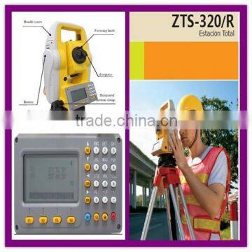
Dual-axis Land Survey Total Station
Application:
1. Mineral survey, exploration and excavation;
2. Construction of railways, highways, Bridges;
3. Irrigation and water conservancy, urban planning and construction;
4. The battlefield preparation, harbor, fortress, airports and military engineering construction;
5. Precision positioning and installation in shipbuilding and aerospace industry ;
6. The three-dimensional coordinates, the location of measurement, pipeline orientation, cross section measurement of the stuctures;
7. The triangle control survey, topographic survey, cadastral and property measurement
Technical Specification:
Angle measurement (Hz,V)
Detecting system——Absolute encoder
Minimum display——1″/5″/10″(selectable)
Accuracy——2″
Telescope
Magnification——30X
Field of view——1°30′
Minimum focus distance——1.5m
Image——Erect
Compensation
System——Dual-axis
Range——±3′
Resolving power——1″
Distance measurement (IR)
Single prism (good condition)——3000m
Reflective sheet——800m
Accuracy——2mm±2ppm
Measuring time (Repete/Tracking)——1s/0.5s
Reflectorless (RL)
Range (white board reflectivity 90%)——600m
Single prism——>7500m
Accuracy——3mm±2ppm
Measuring time——1.5s
Communication
Internal memory——20000 points (SD card supported)
Interface——RS232, Mini-USB, USB
Data format——ASCII
Operation
Operation system——Real-time operation system
Display——192×96 high-light LED screen, brightness adjustable in 3 level
Keyboard——2 sides alphanumeric backlit crystal keyboard
Laser plummet
Type——Laser point, 4 brightness levels adjustable (Optical plummet is optional)
Accuracy——1mm at 1.5m instrument height
Environmental
meteorological parameter modification——Manually(T-P senser is optional)
Operation temperature——-20℃_+50℃
Storage temperature——-40℃_+70℃
Dust & Water proof——IP66
Power supply
Battery type——BT30 Li-ion battery
Voltage/Capacity——7.4V 3400mAh
Operating time——18 hours(continuous angle measurement every 30 seconds)
Measuring times——Approx. 12000 times
Weight
Weight——3.8kg with battery
Characters
Zenith point measurement without removing the handle
Shortcut measurement key on the side, convenient for surveying
Small and light
Key define
Intelligent checking
Contact Us
- Chongqing Gold Mechanical & Electrical Equipment Co., Ltd.
- Contact nameMichelle Li Chat Now
- Phone86-23-62794421
- AddressNo. 9-10, Jintai Mansion, 23 Nanping West Road
Product Categories
| Drill Rig | Element Analyzer | Geophysical Exploration Equipment | Inclinometer |
| New Products | Seismograph | Well Logging |
New Products
-
GD-C Small Size Mini Groundwater Detector
-
Multiple Sensor Data Logger to measure Temperature, Groundwater Level, Conductivity,
-
CZM-3 Geophysical Proton Magnetometer
-
Digital Hydrographic Echo Sounders For Marine Topographic Surveying
-
Borehole Logging Equipment ( JGS-1B ) Borehole Logging System
-
Gold Mine Detector Long Range Gold Detector
-
720TVL Sony CCD Downhole Inspection Camera, Downhole Vedio Camera
-
Submarine Camera GYGD Underwater Camera
-
Tunnel Site Investigation Using Resistivity Imaging
-
Electrical Resistivity Imaging Survey For Bridge Foundation Investigation
-
2016 New Sale!!! Electric Resistivity and IP Tomography machine
-
Hydrographic Survey Echo Sounders, Depthsounding
-
2016 New!!! Borehole and Water Well Inspection Camera Systems
-
Geophysical Equipment For Underground Water Location Detector
-
2D ERT Machine, Electrical Resistance Tomograph and Resistivity Imaging
-
Dual Borehole Camera System, Borehole Inspection Camera and Underwater Camera
-
850TVL Borehole Camera Inspection, water well camera
-
Dowhole Vedio Camera GYGD Downhole Logging Camera
-
Truck Geophysical Well Logging Car, Well Loger
-
Winch Electric Geological Winch Geophysical Exploration Winch
-
Wireline Well Logging Tool For Resistivity, Natural Gamm, Temperature and Caliper
-
Geophysical Imaging Instrument YYGD Geophysical Borehole Imaging Equipment
-
Bathymetric Survey HD370 Multibeam Bathymetric Survey
-
1000m Motor Power Logging Winch
Popular Searches
- satellite
- gsm
- gps navigator
- gps navigation box
- gps chipset
- car gps
- box gps car navigation
- vehicle device
- gps tracker
- car tracker
- Gps Car Alarm
- Tracking Car Alarm
- gps navigation
- car navigation
- gps navigation system
- Car Gps Tracker
- Gps Tracking System
- Gps Vehicle Tracking System
- Gps Map
- mini antenna satellite
- sim card backup
- car gps navigation
- Navigation & GPS
- gps system
- navigator
- gps device
- portable gps
- Car Navigation Gps
- Tracker Gps
- Gps Tracking
Recommended Products
- GPS for children and elderly, 4G locator for children and babies, anti turning remote tracking for the elderly, anti loss pendant, anti loss device
- 4G wireless GPS locator, car anti-theft pickup positioning, remote tracking tracker, car mounted Beidou anti loss device
- Original SMC IP200-120 cylinder positioner New original authentic
- Hi Target GPS V200 GNSS RTK Receiver with tilt sensor
- Hi Target GPS V200 GNSS RTK Receiver with tilt sensor
- 4 Channel HD Mobile DVR 1080P Public Bus Truck Mdvr GPS 3G 4G Mobile DVR
- Full HD HDD 8CH 1080P DVR para vigilancia por vídeo de seguran?a de veículos
- 107M Series (Type A, Type B, Type C, Type D) Double Antenna Combination Micro Inertial Measurement System
- 105M Series (Type A, Type B, Type C, Type D) Single Antenna Combination Micro Inertial Measurement System
- INS1200 Series Fiber Optic GNSS/INS Integrated Inertial Navigation System of Type A, Type B, Type C, and Type D
- INS900 Series Fiber Optic GNSS/INS Integrated Inertial Navigation System of Type A, Type B, Type C, and Type D
- INS600 Series Fiber Optic GNSS/INS Integrated Inertial Navigation System of Type A, Type B, Type C, and Type D
Find Similar Products By Category
- Electrical & Electronics > GPS > GPS Navigator
- Please Enter your Email Address
- Please enter the content for your inquiry.
We will find the most reliable suppliers for you according to your description.
Send Now-
 Michelle Li
Hi there! Welcome to my shop. Let me know if you have any questions.
Michelle Li
Hi there! Welcome to my shop. Let me know if you have any questions.
Your message has exceeded the limit.
- Contact supplier for lowest price
- Customized Request
- Request Sample
- Request Free Catalogs
Your message has exceeded the limit.
-
Purchase Quantity
-
*Sourcing Details
Your inquiry content must be between 10 to 5000 characters.
-
*Email
Please enter Your valid email address.
-
Mobile