Home > Products > Surveying > 2016 Best China Sale Base and Rover Land RTK position system Hi-target H32 gnss rtk system
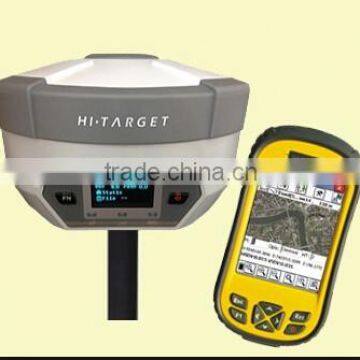


2016 Best China Sale Base and Rover Land RTK position system Hi-target H32 gnss rtk system
USD $0.1 - $0.2
/ Set
1 Set(Min.Order)
- Shanghai
- T/T Credit Card

You May Like
-
 CORS Station GNSS RTK GPS with High Precision
-
Real-Time GPS (RTK GPS) Base and Rover in Measuring Equipment
-
Route Location Best RTK Total Station with high precision
-
Land surveying and mapping satellite navigation GPS RTK/GPS for Land Survey
-
Satellite Survey & Mapping Hot Sale GNSS RTK GPS System Measuring Machine
-
Hi-Target high precision RTK GPS engineering foundation layout
Product Details
| Type | Gps Receiver | Use | Automotive | |
| Screen Size | 2.5 inch | Function | Radio Tuner | |
| Place of Origin | Chongqing, China | Brand Name | Hi-Target | |
| Model Number | H32 | Warranty | 1 Years |
Product Description
DUAL FREQUENCY H32 GNSS RTK HI TARGET GPS RTK Topographic Equipment
Our Services
Our service
1.Your inquiry related to our products or prices will be replied in 24hrs.
2.Well-trained and experienced staffs to answer all your enquires in fluent English
Product Description
KEY FEATURES
Multi Constellation Tracking
120 channels. The H32 is fully compatible with GNSS constellations to track GLONASS, GALILEO, SBAS as well as GPS.
All-in-one Transceiver UHF Radio
The transceiver UHF radio enables the H32’s working mode to be switchable between base and rover in the same receiver. The H32 provides excellent performance in UHF RTK operation with its built-in transceiver UHF radio, which has adjustable transmitting power from o.1 Watt to 2 Watts.
Seamlessly Operation in CORS System
With internal GPRS modem, the H32 works perfectly with corrections from CORS networks in any version of CMR, RTCM without needing to interpret the message but reading seamlessly.
Powerful Battery
Powered by 4400mAh Li-Ion battery.
Static working time 13 - 15 hours
RTK Rover (UHF/GPRS) working time 10 - 12 hours
RTK Base working time 8 - 10 hours
Rugged design, IP67
The special latching technology on flexible flat cables ensures trouble-free operation under impact or vibration. The H32 withstands 2 meters natural fall onto concrete.
Field Controller and Software
There are optional field controllers and software in the H32 package. The controllers with OS Microsoft Windows Mobile 6.5 are fully compatible with the third party software such as Carlson SurvCE, MicroSurvey FieldGenius, Digiterra Explorer, Esri ArcPad etc. besides standard field&GIS software made by HI-TARGET. HI-TARGET controller with WiFi, Bluetooth, and GPRS/3G is completely wireless to connect to any device, collect data and connect to server simultaneously and seamlessly.
Post-processing Software
HI-TARGET Geomatics Office (HGO) software provides total GNSS solution with a complete suite of programs to support HI-TARGET GNSS receivers. Standard Rinex data and HI-TARGET raw data can be processed flexibly and easily.
Company Information
Hi-Target Partner Meeting in June 2015
Contact Us
- Chongqing Huobo Surveying Instruments Co., Ltd.
- Contact nameMichelle Li Chat Now
- Phone0086-023-62794421
- AddressNo. 7-8, No. 23, Nanping West Road, Nanping Street
Product Categories
| Drilling Rig | Mapping GIS | New Products | Surveying |
New Products
-
Municipal Land Surveying RTK GPS Right of Way Survey equipment
-
Cheap Sell 350m Reflectorless Total Station
-
High Precision total station Surveying Instrument Hi target
-
Total Station Geographic Surveying Instrument with Reflectorless
-
Topographic Survey of Total Station Survey Instrument
-
Precision Total Station for Civil Engineering
-
Hot-Selling Reflectorless laser Total Station for land Surveying
-
Hot-Selling Electrical Total Station for Construction
-
Hot-Selling Optical Mechanical and Electrical Total Station for Civil Engineering
-
High accuracy GNSS GPS Reveiver Base and Rover RTK Survey Equipment
-
Dual Frequency high precision GPS Navigation GPS RTK Receiver Surveying equipment
-
Surveying and Buildings Survey GPS/Gnss/ GLONSS Rtk Instruments gps for land survey
-
Surveying and Civil Engineering Design GPS/Gnss/ GLONSS Rtk Instruments
-
Brand New RTK GPS GNSS GLONSS Surveying Equipment Made in China for sale
-
New Releasing RTK GPS GLONSS Base and Rover Surveying Equipment Made in China for sale
-
Light Weight and Easy Operation RTK GPS GNSS GLONSS Base and Rover Surveying Equipment
-
Surveying Equipment of HiTarget RTK GPS GNSS GLONSS Base and Rover
-
Easy operation high precision GLONASS+GPS Satellite survey GNSS RTK GPS
Popular Searches
- satellite
- gsm
- gps navigator
- gps navigation box
- gps chipset
- car gps
- box gps car navigation
- vehicle device
- gps tracker
- car tracker
- Gps Car Alarm
- Tracking Car Alarm
- gps navigation
- car navigation
- gps navigation system
- Car Gps Tracker
- Gps Tracking System
- Gps Vehicle Tracking System
- Gps Map
- mini antenna satellite
- sim card backup
- car gps navigation
- Navigation & GPS
- gps system
- navigator
- gps device
- portable gps
- Car Navigation Gps
- Tracker Gps
- Gps Tracking
Recommended Products
- GPS for children and elderly, 4G locator for children and babies, anti turning remote tracking for the elderly, anti loss pendant, anti loss device
- 4G wireless GPS locator, car anti-theft pickup positioning, remote tracking tracker, car mounted Beidou anti loss device
- Original SMC IP200-120 cylinder positioner New original authentic
- Hi Target GPS V200 GNSS RTK Receiver with tilt sensor
- Hi Target GPS V200 GNSS RTK Receiver with tilt sensor
- 4 Channel HD Mobile DVR 1080P Public Bus Truck Mdvr GPS 3G 4G Mobile DVR
- Full HD HDD 8CH 1080P DVR para vigilancia por vídeo de seguran?a de veículos
- 107M Series (Type A, Type B, Type C, Type D) Double Antenna Combination Micro Inertial Measurement System
- 105M Series (Type A, Type B, Type C, Type D) Single Antenna Combination Micro Inertial Measurement System
- INS1200 Series Fiber Optic GNSS/INS Integrated Inertial Navigation System of Type A, Type B, Type C, and Type D
- INS900 Series Fiber Optic GNSS/INS Integrated Inertial Navigation System of Type A, Type B, Type C, and Type D
- INS600 Series Fiber Optic GNSS/INS Integrated Inertial Navigation System of Type A, Type B, Type C, and Type D
Find Similar Products By Category
- Electrical & Electronics > GPS > GPS Navigator
- Please Enter your Email Address
- Please enter the content for your inquiry.
We will find the most reliable suppliers for you according to your description.
Send Now
Chongqing Huobo Surveying Instruments Co., Ltd.
AIBot OnlineThis conversation is AI-generated. Contact manufacturer before transaction to confirm info.
-
 Michelle Li
Hi there! Welcome to my shop. Let me know if you have any questions.
Michelle Li
Hi there! Welcome to my shop. Let me know if you have any questions.
Your message has exceeded the limit.
- Contact supplier for lowest price
- Customized Request
- Request Sample
- Request Free Catalogs
Your message has exceeded the limit.
-
Purchase Quantity
-
*Sourcing Details
Your inquiry content must be between 10 to 5000 characters.
-
*Email
Please enter Your valid email address.
-
Mobile