Professional Land Survey GPS L1,L2 RTK GPS
USD $1 - $10
/ Set
1 Set(Min.Order)
- Chongqing
- T/T Credit Card

You May Like
-
 Popular GNSS RTK GPS with Stable Performance,HI-TARGET RTK GPS
-
New Condition HI-TARGET RTK GPS with Competitive Quality and Price
-
GeoMax Zipp20 WinCE Series Total Station
-
Hot Sale HI-TARGET H32 GNSS RTK GPS
-
Made in China Hi target Long Range HS450 3D Laser Scanner Price
-
Map Generation or Building Surveillance with New Effiective Tool Hi-Tagret Laser 3D Scanner
Product Details
| Type | Gps Receiver | Use | Other, Surveying and Mapping | |
| Screen Size | Other, 3.7inch controller | Function | Bluetooth-enabled, Mp3/Mp4, Radio Tuner, Touch Screen | |
| Place of Origin | Chongqing, China | Brand Name | Hi-Target Land Survey RTK GPS | |
| Model Number | H32 Land Survey RTK GPS | Warranty | 12 Months |
Product Description
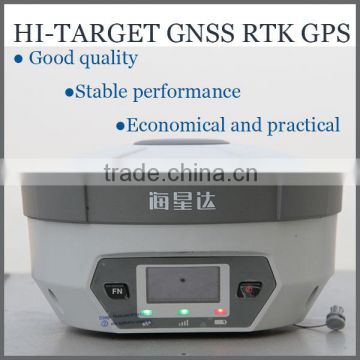
Professional Land Survey GPS L1,L2 RTK GPS
Originated from HI-TARGET’s sophisticated GNSS technology, the H32 RTK GPS is a very competitive GNSS RTK system on the current market with its rugged design and affordable price.
The H32’s housing is made of General Electric Xenoy 5220U polymer resin to handle severe and harsh filed conditions. With its unique internal design, it can perfectly avoid or lessen obstruction and multipath effect to ensure superior positioning capability.
The H32 RTK GPS’s front control panel with super bright OLED display screen (Resolution 128x64) makes the work more intuitive. No matter it is in the dark or strong sunshine, the screen is comfortably readable to eyes.
Technical Parameters of the Land Survey GPS:
| Measurement | • 120 Channels |
• Proven NovAtel GNSS technology | |
• Multipath mitigating technology | |
• Auxiliary strobe signals, including a configurable output for time synchronization and mark inputs | |
| Satellite signals tracked simultaneously | |
GPS: L1, L2, L2C | |
GLONASS: L1, L2 | |
Galileo: E1 | |
GIOVE-A/GIOVE-B (test) | |
BDS/Compass | |
SBAS | |
QZSS | |
| Positioning Perfromance | Static and Fast Static GNSS surveying |
Horizontal: 2.5mm+0.5ppm RMS | |
Vertical: 5mm+0.5ppm RMS | |
Post Processing Kinematic | |
*(PPK / Stop & Go) GNSS surveying | |
Horizontal: 1cm+1ppm RMS | |
Vertical: 2.5cm+1ppm RMS | |
Initialization time: typically 10 minutes for base while 5 minutes for rover | |
Initialization reliability: typically > 99.9% | |
*Real-time Kinematic (RTK) surveying | |
Horizontal: 10mm+1ppm RMS | |
Vertical: 20mm+1ppm RMS | |
Initialization time: typically < 10 seconds | |
Initialization reliability: typically > 99.9% | |
*Code Differential GNSS positioning | |
Horizontal: 25cm+1ppm RMS | |
Vertical: 50cm+1ppm RMS | |
SBAS: 0.60m Horizontal | |
Hardware | Physical |
Dimensions (w x H): 16.5 cm x 10.5 cm (6.50 in x 4.13 in) | |
Weight: 1.75kg (3.86lb) with internal battery, internal radio, standard UHF antenna | |
Operating temperature: -45℃to +65℃ (-49℉ to +149℉) | |
Storage temperature: -55℃ to +85℃ (-67℉ to +185℉) | |
Humidity: 100%, considering | |
Water/dustproof: IP67 dustproof, protected from temporary immersion to depth of 1m (3.28ft). | |
Shock and Vibration: Designed to survive a 2m (6.56ft) natural fall onto concrete. | |
Display: 128×64 resolution, 1.54 inch OLED screen | |
Electrical | |
Power 6V to 28V DC external power input | |
Power consumption 2.5W | |
Automatic Switching between internal power and external power | |
Rechargeable, removable 7.4V, 4400mAh Lithium-Ion battery in internal battery compartment | |
Internal battery life | |
Static 13 - 15 hours | |
RTK Rover (UHF/GPRS) 10 - 12 hours | |
RTK Base 8 - 10 hours | |
I/O interface | |
1 x Bluetooth | |
1 x standard USB2.0 port | |
2 x RS232 serial port | |
2 x DC power input (8-pin & 5-pin) | |
Communication and Data Storage | GPRS/GSM |
Fully integrated, fully sealed internal GPRS/GSM | |
Network RTK (via CORS) range 20-50km | |
HI-TARGET internal UHF radio (standard) | |
Frequency: 460 MHz with 116 channels | |
Transmitting Power: 0.1W, 1W, 2W adjustable | |
Transmitting Speed: Up to 19.2Kbps | |
Working range: 3~5Km typical, 8~10km optimal | |
HI-TARGET External UHF radio (standard) | |
Frequency: 460 MHz with 116 channels | |
Transmitting Power: 5W, 10W, 20W, 30W adjustable | |
Transmitting Speed: Up to 19.2Kbps | |
Working Range: 8~10Km typical, 15~20km optimal | |
Support other external communication device | |
For example, external GSM modem. | |
Data storage | |
64MB internal memory | |
Data formats | |
(1Hz positioning output, up to 50 Hz - depends on installed option) | |
CMR: CMR+, CMR input and output | |
RTCM: RTCM 2.1, 2.3, 3.0, 3.1 input and output | |
RTCA: RTCA | |
Navigationoutputs: NMEA-0183, NovAtel ASCII and Binary logs |
*The Main Features of The Land Survey RTK GPS:
Multi Constellation Tracking
120 channels. The H32 is fully compatible with GNSS constellations to track GLONASS, GALILEO, SBAS as well as GPS.
All-in-one Transceiver UHF Radio
The transceiver UHF radio enables the H32’s working mode to be switchable between base and rover in the same receiver. The H32 provides excellent performance in UHF RTK operation with its built-in transceiver UHF radio, which has adjustable transmitting power from o.1 Watt to 2 Watts.
Seamlessly Operation in CORS System
With internal GPRS modem, the H32 works perfectly with corrections from CORS networks in any version of CMR, RTCM without needing to interpret the message but reading seamlessly.
Powerful Battery
Powered by 4400mAh Li-Ion battery.
Static working time 13 - 15 hours
RTK Rover (UHF/GPRS) working time 10 - 12 hours
RTK Base working time 8 - 10 hours
Rugged design, IP67
The special latching technology on flexible flat cables ensures trouble-free operation under impact or vibration. The H32 withstands 2 meters natural fall onto concrete.
Field Controller and Software
There are optional field controllers and software in the H32 package. The controllers with OS Microsoft Windows Mobile 6.5 are fully compatible with the third party software such as Carlson SurvCE, MicroSurvey FieldGenius, Digiterra Explorer, Esri ArcPad etc. besides standard field&GIS software made by HI-TARGET. HI-TARGET controller with WiFi, Bluetooth, and GPRS/3G is completely wireless to connect to any device, collect data and connect to server simultaneously and seamlessly.
Post-processing Software
HI-TARGET Geomatics Office (HGO) software provides total GNSS solution with a complete suite of programs to support HI-TARGET GNSS receivers. Standard Rinex data and HI-TARGET raw data can be processed flexibly and easily.
*Why Choose US?
Shows:
Contact US
Contact Us
- Chongqing Huobo Surveying Instruments Co., Ltd.
- Contact nameMichelle Li Chat Now
- Phone0086-023-62794421
- AddressNo. 7-8, No. 23, Nanping West Road, Nanping Street
Product Categories
| Drilling Rig | Mapping GIS | New Products | Surveying |
New Products
-
Hi-Target HS450 Three Dimensional Laser Scanner for sale
-
Buliding Digital cultural heritage with Hi-Target HS450 3D laser Scanner System
-
HS450 High-precision 3D Laser Scanner for Landslide Treatment
-
High Processing Efficiency of Point Cloud with Hi-Target HS450 3D Laser Scanner for sale
-
Hi-Target HS450 3D Laser Scanner Price 3D Laser Scanning Survey System
-
0.5m-400m Long measuring range Hi-Target HS450 3D Laser Scanner Price
-
Hi-Target HS450 High Precision 3D Laser Scanner
-
DZS-1 Earthquake surveying deep digital seismograph with ISO certificated
-
Underground water detector, Multi-Function DC Resistivity & IP Instruments
-
Geophysical surveying meter DZQ6B Engineering Seismograph (Surface Wave Instrument)
-
Metal and water detector, Multi-Function DC Resistivity & IP Instruments
-
Water finder meter, Multi-Function DC Resistivity & IP Instruments
-
Detector, Multi-Function DC Resistivity & IP Instruments
-
BRAND NEW High Quality Original Hi-Target BL5000 Battery For Hi-Target RTK GNSS
-
Hi-Target BL-5000 High Quality battery For Hi-Target RTK GNSS GPS V30,V60,V90
-
Hi-target battery , RTK GPS/Battery, H32,V30, V60,BL-5000 RTK GPS Host battery
-
BL-5000 Hi-target GPS RTK Battery For Series HI-Target RTK GPS
-
DZD-6A Underground water detector
-
Mineral resources detactor DDC-8 electric Resistivity Meter
-
Mineral & water finder DDC-8 electric Resistivity Meter
-
Waterproof Dual Frequency high precision GPS Navigation Gps receiver or tracker
-
Best Reflectorless Total Station for Surveys
-
Portable Navigation System GPS GNSS RTK Survey Instruments
-
Cheap Total Stions with no prism Made in China for slae
Popular Searches
- satellite
- gsm
- gps navigator
- gps navigation box
- gps chipset
- car gps
- box gps car navigation
- vehicle device
- gps tracker
- car tracker
- Gps Car Alarm
- Tracking Car Alarm
- gps navigation
- car navigation
- gps navigation system
- Car Gps Tracker
- Gps Tracking System
- Gps Vehicle Tracking System
- Gps Map
- mini antenna satellite
- sim card backup
- car gps navigation
- Navigation & GPS
- gps system
- navigator
- gps device
- portable gps
- Car Navigation Gps
- Tracker Gps
- Gps Tracking
Recommended Products
- GPS for children and elderly, 4G locator for children and babies, anti turning remote tracking for the elderly, anti loss pendant, anti loss device
- 4G wireless GPS locator, car anti-theft pickup positioning, remote tracking tracker, car mounted Beidou anti loss device
- Original SMC IP200-120 cylinder positioner New original authentic
- Hi Target GPS V200 GNSS RTK Receiver with tilt sensor
- Hi Target GPS V200 GNSS RTK Receiver with tilt sensor
- 4 Channel HD Mobile DVR 1080P Public Bus Truck Mdvr GPS 3G 4G Mobile DVR
- Full HD HDD 8CH 1080P DVR para vigilancia por vídeo de seguran?a de veículos
- 107M Series (Type A, Type B, Type C, Type D) Double Antenna Combination Micro Inertial Measurement System
- 105M Series (Type A, Type B, Type C, Type D) Single Antenna Combination Micro Inertial Measurement System
- INS1200 Series Fiber Optic GNSS/INS Integrated Inertial Navigation System of Type A, Type B, Type C, and Type D
- INS900 Series Fiber Optic GNSS/INS Integrated Inertial Navigation System of Type A, Type B, Type C, and Type D
- INS600 Series Fiber Optic GNSS/INS Integrated Inertial Navigation System of Type A, Type B, Type C, and Type D
Find Similar Products By Category
- Electrical & Electronics > GPS > GPS Navigator
- Please Enter your Email Address
- Please enter the content for your inquiry.
We will find the most reliable suppliers for you according to your description.
Send Now
Chongqing Huobo Surveying Instruments Co., Ltd.
AIBot OnlineThis conversation is AI-generated. Contact manufacturer before transaction to confirm info.
-
 Michelle Li
Hi there! Welcome to my shop. Let me know if you have any questions.
Michelle Li
Hi there! Welcome to my shop. Let me know if you have any questions.
Your message has exceeded the limit.
- Contact supplier for lowest price
- Customized Request
- Request Sample
- Request Free Catalogs
Your message has exceeded the limit.
-
Purchase Quantity
-
*Sourcing Details
Your inquiry content must be between 10 to 5000 characters.
-
*Email
Please enter Your valid email address.
-
Mobile