Home > Products > Mapping GIS > Level Measuring Handheld GIS Data Collector


Level Measuring Handheld GIS Data Collector
- 100 Set / Sets per Month
- Chongqing China
- T/T

You May Like
-
 Popular GPS L1,L2+GLONASS Land Survey GPS
-
Chinese Famous Dual Frequency GIS Collector with CE Certification
-
Hi-Target High Accuracy Good Quality Handheld GIS Collector
-
Qstar8 single point positioning new condition gps receiver
-
RTK GPS Receiver with High Quality GPS System Qmini MP GIS Collector
-
Light and flexible mini GPS/BDS GPS positioning equipment
Product Details
| Type | Gps Navigator | Use | Automotive | |
| Screen Size | Other | Function | Bluetooth-enabled | |
| Place of Origin | Chongqing, China | Brand Name | Hi-target | |
| Model Number | Qmini MP | Warranty | 1 Years |
Product Description
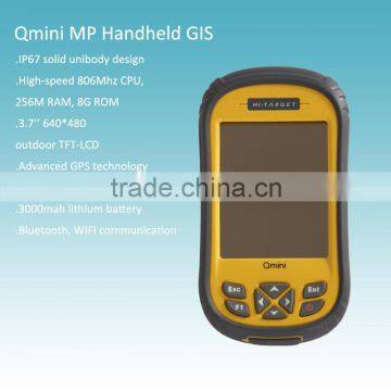
Level Measuring Handheld GIS Data Collector
High-quality IP level:
With solid unibody design, this handheld gis gps reaches IP67 level, 1.5m free fall anti-shock fits various of rough environment.
Powerful CPU:
Equiped with high-speed 806Mhz CPU, 256M RAM, 8G ROM. This handheld gis gps can provide you smooth operating experience and large storage space.
3.7’’ TFT-LCD:
Equiped with a 3.7’’ high-resolution (640*480) outdoor TFT-LCD, this handheld gis gps has high level sunlight readability.
Advanced GPS technology:
As the leader of Chinese high accuracy GNSS industry, we can provide you with higher GPS positioning accuracy and reliability.
Advanced PPP (Precise Point Positioning) technology provides this handheld gis gps higher point positioning accuracy.
Phone function
With built-in 3G communication module, remote data communication on this xxx can be easily done. Voice calls function can be applied on this handheld gis gps with microphone and speaker.
5 mega-pixel camera:
This handheld gis gps is integrated with a 5mp high-resolution camera and flash LED.
Large capacity lithium battery:
Lithium battery with 3000mah ultra-large capacity, this handheld gis gps can provide you 8 hours of continuous working time.
More features:
Bluetooth, WIFI communication.
System Configuration:
Operating system: Windows Mobile 6.5
Processor: 806 MHz
Ram: 256 MB RAM
Flash Memory: 8 GB
Display: 3.7 inch LED, 640*480 resolution
GPS Features:
DGPS L1&BDS B1
Built-in high sensitivity anti-interference GPS antenna
Update rate: 1 fix/s (user configurable)
Update rate: 1 Hz (configurable w/future FW 2 Hz Max)
Time to first fix (TTFF): 35 seconds (typical)
Position Accuracy:
Single Point Positioning: 5M
Application Functions:
T5 million pixel camera with LED
Built-in speaker
Communication interface:
Bluetooth
Mini USB
WIFI:802.11b/g
Micro SD card slot, support up to 32GB
Built-in 3G module
Power Supply:
3.7V, 3100mAh lithium battery, up to 8 hours continuous work, online charging.
Physical Properties:
10 keys, with the four arrow keys
Size: 152*82*32mm
Weight: 315g (with battery)
Operating temperature: -20c~+70c
Storage temperature: -30c~+80c
Dustproof/waterproof: IP65
Anti-shock: 1.5m free fall
Any question, please feel free to contact:
Contact Us
- Chongqing Huobo Surveying Instruments Co., Ltd.
- Contact nameMichelle Li Chat Now
- Phone0086-023-62794421
- AddressNo. 7-8, No. 23, Nanping West Road, Nanping Street
Product Categories
| Drilling Rig | Mapping GIS | New Products | Surveying |
New Products
-
New Condition Handheld GPS in Survey Equipment
-
Modern design new GPS receiver with CE certification
-
IP67 waterproof dustproof cheap and fine handheld GPS controler with RTK GPS
-
Handheld GPS Survey Qmini MP GPS Receiver with Windows Operation System
-
Land Survey GIS Collector Qmini MP Field Controller
-
Surveying and mapping GPS tracker/GPS receiver
-
High accuracy GPS navigation device for sale
-
Qmini MP widely used handheld GPS for high accuracy
-
CM Level Accuracy Handheld Mapping RTK GIS
-
Qstar 8 High precision RTK Handheld Mobile GPS
-
High Precision Handheld RTK GPS Instrument
-
Level Measuring Handheld GIS GPS Instrument
-
High Precision Handheld GPS Navigator
-
Top Quality High Accuracy GIS Data Collector
-
Mini handheld GPS receiver in survey equipment
-
New Land Manage Survey Equipment Handheld GIS Data Collector
-
Dual Frequency GPS L1,L2 GIS Collector for Sale
-
New Handheld GIS Collector with Bright Light Against OLED
-
806Mhz hi-speed CPU GIS Collector for geological survey
-
Widely Usde High Accuracy GIS Collector Handheld GPS
-
GPS+GLONASS Dual Satellites Positioning GIS Collector
-
New Condition Dual Frequency GIS Date Collector for Signal
-
Dual Frequency Handheld GPS with Antenna
-
Land registration and management GIS data collecor handheld GPS
Popular Searches
- satellite
- gsm
- gps navigator
- gps navigation box
- gps chipset
- car gps
- box gps car navigation
- vehicle device
- gps tracker
- car tracker
- Gps Car Alarm
- Tracking Car Alarm
- gps navigation
- car navigation
- gps navigation system
- Car Gps Tracker
- Gps Tracking System
- Gps Vehicle Tracking System
- Gps Map
- mini antenna satellite
- sim card backup
- car gps navigation
- Navigation & GPS
- gps system
- navigator
- gps device
- portable gps
- Car Navigation Gps
- Tracker Gps
- Gps Tracking
Recommended Products
- GPS for children and elderly, 4G locator for children and babies, anti turning remote tracking for the elderly, anti loss pendant, anti loss device
- 4G wireless GPS locator, car anti-theft pickup positioning, remote tracking tracker, car mounted Beidou anti loss device
- Original SMC IP200-120 cylinder positioner New original authentic
- Hi Target GPS V200 GNSS RTK Receiver with tilt sensor
- Hi Target GPS V200 GNSS RTK Receiver with tilt sensor
- 4 Channel HD Mobile DVR 1080P Public Bus Truck Mdvr GPS 3G 4G Mobile DVR
- Full HD HDD 8CH 1080P DVR para vigilancia por vídeo de seguran?a de veículos
- 107M Series (Type A, Type B, Type C, Type D) Double Antenna Combination Micro Inertial Measurement System
- 105M Series (Type A, Type B, Type C, Type D) Single Antenna Combination Micro Inertial Measurement System
- INS1200 Series Fiber Optic GNSS/INS Integrated Inertial Navigation System of Type A, Type B, Type C, and Type D
- INS900 Series Fiber Optic GNSS/INS Integrated Inertial Navigation System of Type A, Type B, Type C, and Type D
- INS600 Series Fiber Optic GNSS/INS Integrated Inertial Navigation System of Type A, Type B, Type C, and Type D
Find Similar Products By Category
- Electrical & Electronics > GPS > GPS Navigator
- Please Enter your Email Address
- Please enter the content for your inquiry.
We will find the most reliable suppliers for you according to your description.
Send Now-
 Michelle Li
Hi there! Welcome to my shop. Let me know if you have any questions.
Michelle Li
Hi there! Welcome to my shop. Let me know if you have any questions.
Your message has exceeded the limit.
- Contact supplier for lowest price
- Customized Request
- Request Sample
- Request Free Catalogs
Your message has exceeded the limit.
-
Purchase Quantity
-
*Sourcing Details
Your inquiry content must be between 10 to 5000 characters.
-
*Email
Please enter Your valid email address.
-
Mobile