Home > Products > Mapping GIS > Hunting,Sailing,hiking with best handheld GPS with best positioning navigation equipment


Hunting,Sailing,hiking with best handheld GPS with best positioning navigation equipment
- 100 Set / Sets per Month
- Shanghai
- T/T Credit Card

You May Like
-
 GPS Tracking with Windows CE Operation System handheld GPS GIS data collector
-
Cheap selling Grid inspection,Petroleum conduit patrolling with handheld GPS
-
Best handheld GPS for Pipeline inspector with 3.5inch Touch Screen
-
New condition handheld GPS for sale GPS navigation equipment
-
Hi-target land surveying and mapping GPS equipment handheld GIS collector
-
Popular high precision tracking GPS land surveying instruments
Product Details
| Type | Gps Receiver | Use | Hand Held | |
| Screen Size | 3.5 inch | Function | Bluetooth-enabled, DVD/VCD, Mp3/Mp4, Photo Viewer, Radio Tuner, Touch Screen | |
| Place of Origin | Chongqing, China | Brand Name | Hi-Target | |
| Model Number | Qcool i7 | Warranty | 12 Months |
Product Description
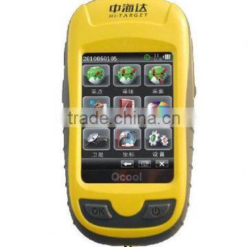
Hi-Target Qcool i7 Handheld GPS
Hi –Target Qcool i7 Handheld GPS is adding the bluetooth and other professional GIS Data Collector functions comparing with Qcool i3 and Qcool i5. With installed the professional GIS data collector software, Qcool i7 can provide secondary development of SDK, support GPS+GLONSS double stars position. Qcool handheld GPS is smart ,high speed,stylish handheld GPS with integrated the many years‘ experience in GPS technology.
Feartures:
l With Microsoft Windows CE Operation System
l Customized with GIS function
Compatible with Qcool software of data collection and navigation
Professional GIS software Hi-Q for industry
l 533 MHz high-speed CPU,2G data storage
l 2.8inch color touch screen
l GPS+GLONASS Positioning
l Installed with Electronic Compass, Barometric Measurement , Hermometer
l Waterproof and Dustproof IP67, Anti-shock: 1.5 m free fall
Technical Parameters:
1. Operating system: Windows CE 5.0
2. Processor: 533 MHz
3. RAM: 2G
4. Display: 2.8 inch LED, 240×320 resolution
5. GPS L1&SBAS L1 C/A
6. Built-in high sensitivity anti-interference GPS antenna
7. GPS Single Point Positioning: 5m
8. SBAS code difference :1-3m
9. Install the GIS software for collection Ponit,Line and Surface
10. Directly way to measuring length, area the calculate and summary the data
12.Support vehicle navigation
13.Supports third-party application software installation
14.Bluetooth wireless communication function
16. Directly exported and the industry commonly used GIS formats, including .shp, .mif, .dxf, .csv, .dml other formats
17. Support point POI points, lines and imported map, you can import digital maps as the base map, the collected data can be superimposed display
18.Support professional mobile GIS software to install applications, to achieve more professional GIS features.
Contact Us
- Chongqing Huobo Surveying Instruments Co., Ltd.
- Contact nameMichelle Li Chat Now
- Phone0086-023-62794421
- AddressNo. 7-8, No. 23, Nanping West Road, Nanping Street
Product Categories
| Drilling Rig | Mapping GIS | New Products | Surveying |
New Products
-
China Brand Data Collector Android 3.7 Inch GIS GPS Price
-
Windows Mobile 6.5 SBAS 1-3m Outdoor Usage GIS Best Handheld GPS
-
Brand New Marine Geodetic Survey Handheld GPS Qstar8
-
Popular GIS Equipment accept GPS GLONASS Signal
-
Handheld New Mapping GIS Equipment Qstar 8
-
Qstar 8 GIS Collector Made in China
-
Hot Sale GIS Equipment for surveying and mapping
-
New condition handheld gps Qstar 8
-
Mapping GIS Equipment Qstar 8
-
High accuracy mobile GIS products
-
New model Qpad RTK GPS connect with CORS
-
Photogrammetric Mapping NovAtel Dual-frequency board GNSS RTK Base Rover UVA GPS Drone GPS
-
CM Positioning Level GNSS RTK Receiver Base and rover for UAV Drone Aerial Imagery
-
Light Weight Real Time Coordinate Collection GNSS RTK Receiver for Drone Photogrammetric
-
High Accuracy Drone GPS RTK System for Photogrammetric Surveys
-
2016 New Model High Accuracy Qpad X5 GIS Collector
-
Qpad handheld GPS with RTK Survey Model
-
7" big screen handheld GPS for GIS data collect
-
New Handheld GPS to Collect GIS Data
-
Handheld GNSS GIS Data Collector with WIFI,Bluetooth,Dual SIM card
-
HOT Sale Hi Target Handheld GPS Land Survey GIS Collector
-
Touch Screen Hi-Target Qstar 8 Best Handheld GPS Measuring Device
-
Hi-target Qstar 8 GIS Collectors GIS land surveying
-
Hi-target Qstar 8 hanheld GPS RTK Network Rover GPS for Cadastral Survey
Popular Searches
- satellite
- gsm
- gps navigator
- gps navigation box
- gps chipset
- car gps
- box gps car navigation
- vehicle device
- gps tracker
- car tracker
- Gps Car Alarm
- Tracking Car Alarm
- gps navigation
- car navigation
- gps navigation system
- Car Gps Tracker
- Gps Tracking System
- Gps Vehicle Tracking System
- Gps Map
- mini antenna satellite
- sim card backup
- car gps navigation
- Navigation & GPS
- gps system
- navigator
- gps device
- portable gps
- Car Navigation Gps
- Tracker Gps
- Gps Tracking
Recommended Products
- Original SMC IP200-120 cylinder positioner New original authentic
- Hi Target GPS V200 GNSS RTK Receiver with tilt sensor
- Hi Target GPS V200 GNSS RTK Receiver with tilt sensor
- 4 Channel HD Mobile DVR 1080P Public Bus Truck Mdvr GPS 3G 4G Mobile DVR
- Full HD HDD 8CH 1080P DVR para vigilancia por vídeo de seguran?a de veículos
- 107M Series (Type A, Type B, Type C, Type D) Double Antenna Combination Micro Inertial Measurement System
- 105M Series (Type A, Type B, Type C, Type D) Single Antenna Combination Micro Inertial Measurement System
- INS1200 Series Fiber Optic GNSS/INS Integrated Inertial Navigation System of Type A, Type B, Type C, and Type D
- INS900 Series Fiber Optic GNSS/INS Integrated Inertial Navigation System of Type A, Type B, Type C, and Type D
- INS600 Series Fiber Optic GNSS/INS Integrated Inertial Navigation System of Type A, Type B, Type C, and Type D
- INS300 Series Fiber Optic GNSS/INS Integrated Inertial Navigation System of Type A, Type B, Type C, and Type D
- FOG900 Series A-type, B-type, C-type, D-type Fiber Optic Gyroscope
Find Similar Products By Category
- Electrical & Electronics > GPS > GPS Navigator
- Please Enter your Email Address
- Please enter the content for your inquiry.
We will find the most reliable suppliers for you according to your description.
Send Now-
 Michelle Li
Hi there! Welcome to my shop. Let me know if you have any questions.
Michelle Li
Hi there! Welcome to my shop. Let me know if you have any questions.
Your message has exceeded the limit.
- Contact supplier for lowest price
- Customized Request
- Request Sample
- Request Free Catalogs
Your message has exceeded the limit.
-
Purchase Quantity
-
*Sourcing Details
Your inquiry content must be between 10 to 5000 characters.
-
*Email
Please enter Your valid email address.
-
Mobile