Home > Products > GPS Tracker > Computer/Laptop Vehicle GPS Tracking Software for Maximum 200 Cars (SMS&GPRS)
Computer/Laptop Vehicle GPS Tracking Software for Maximum 200 Cars (SMS&GPRS)
- 1 Piece / Pieces per Month
- T/T Credit Card PayPal

You May Like
Product Details
| Type | Gps Tracker | Use | Automotive | |
| Place of Origin | Guangdong, China | Brand Name | OEM,ODM | |
| Model Number | Maptrack SA&SB |
Product Description
For the first solution, user will think if there's more function like: I want to see my car on the map. I f there's several cars, what shall I do? Can I store all the coordinates for a trace?
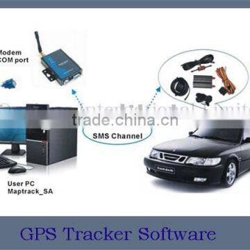
The solution II & III has more exciting functions let user to make it. User need connect a GSM modem with computer, and then install the software to PC. The software runs into mode: GSM or GPRS. If there's no internet connection, you could use GSM mode; If yes, user could track real-time and see his car on the map.
The difference between solution II & III is the working mode:
Solution II: SMS, This solution can show the location on the map. It could work without internet connection. And user could control the cost for tracking which only come from SMS charge. But the speed to send SMS is slow. It's can not track real time and has no functions as GPRS.
Solution II: SMS, GGMapTrack_SA MxMapTrack_SA
This solution can show the location on the map. It could work without internet connection. And user could control the cost for tracking which Only come from SMS charge. But the speed to send SMS is slow. It's can not track real time and has no functions as GPRS.
GGMapTrack_SA is based on the Google Earth, the software embedded in Google Earth, through the serial port with the ETM (SMS MODEM) Connected. It can remote management and control of vehicles through GSM network, and real-time display current location of vehicles on Google Earth. (SMS)
MxMapTrack_SA is Support MapInfo Map, and through the serial port with the ETM (SMS MODEM) connected. It can remote management And control of vehicles through GSM network, It used MapInfo Map and real-time display current location of vehicles on Map. And can get the detail address of vehicle. (SMS)
Solution III: GPRS & SMS.
This solution can show user's car real time on the map. And it use GPRS to transfer information, it has more powerful function as the mileage, history trace and so on.
Solution III: GPRS & SMS . GGMapTrack_SB MxMapTrack_SB
This solution can show user's car real time on the map. And it use GPRS to transfer information, it has more powerful function as the mileage, History trace and so on.
GGMapTrack_SB is based on the Google Earth, the software embedded in Google Earth, with this software, you no longer need to set up the Server. Without fixed IP. Through TCP / IP with the device that installed in vehicles for communication, it can remote management and control Of vehicles, and real-time display current location of vehicles on Google Earth. (GPRS, SMS)
MxMapTrack_SB is support MapInfo Map. With this software, you no longer need to set up the server. Without fixed IP. Through TCP / IP with The device that installed in vehicles for communication, it can remote management and control of vehicles, It used MapInfo Map and real-time display current location of vehicles on Map. And can get the detail address of vehicle. (GPRS, SMS) Both of them have the vehicles information management function. Because it is designed for one computer, so the suggestion MAX 50 vehicles.

Contact Us
- Shenzhen Ouxiang Electronics Co., Ltd.
- Contact nameWendy Yang Chat Now
- Phone0086-755-27043175
- AddressRoom1316, Hongyu building ,Longguan east road, Longhua new distric ,Shenzhen,China;Factory TongFuyu Industry Area,Dalang Village,Longhua, Shenzhen,China, Shenzhen, Guangdong
Product Categories
New Products
-
GSM/GPRS GPS tracker
-
gps motorcycle tracker manufacturers OX-ET301B
-
GPS Tracking System with SOS Button
-
Waterproof Wrist Watch Personal GPS Trackers
-
Newest Vehicle GPS Tracking System with Camera & Fuel Sensor
-
Waterproof 1080P Full HD 120 degrees Wild Hunting Trail Camera bulit-in 42pcs IR 850nm/940nm LED for 20m night time vision
-
12MP Trail Hunting Camera Night Vision IP56 Trail Camera Infrared Huntin
-
12MP W ildlife Hunting Trail Camera , Waterproof Trail Camera
-
12MP Waterproof Mini Night Vision Infrared Wildlife Hunting Trail Camera
-
Trail Hunting Camera 12mp HD Weather-proof Invisible IR Hunting Camera
-
12 MP HD Wide Angle PIR motion detection hunting camera wildlife trail camera
-
Original Trail Farm Hunting Camera Cam 2.4' LCD Bulit-in 42pcs LED 12MP 1080P Hunting Wildlife Trail Camera support night vision
-
wireless H.264 wifi 2p2 wireless 2mp ip camera
-
ir viewerframe mode network nvr wifi ip camera system w/ blinking red led light
-
wireless outdoor dome ptz ip camera
-
wireless 1080p hd mini ip cctv security camera shenzhen
-
cheap p2p nvsip network camera camara ip
-
H.264 HD IR ONVIF NVR ip camera sim card with prices
Popular Searches
- satellite
- gsm
- gps navigator
- gps navigation box
- gps chipset
- car gps
- box gps car navigation
- vehicle device
- gps tracker
- car tracker
- Gps Car Alarm
- Tracking Car Alarm
- gps navigation
- car navigation
- gps navigation system
- Car Gps Tracker
- Gps Tracking System
- Gps Vehicle Tracking System
- Gps Map
- mini antenna satellite
- sim card backup
- car gps navigation
- Navigation & GPS
- gps system
- navigator
- gps device
- portable gps
- Car Navigation Gps
- Tracker Gps
- Gps Tracking
Recommended Products
- Original SMC IP200-120 cylinder positioner New original authentic
- Hi Target GPS V200 GNSS RTK Receiver with tilt sensor
- Hi Target GPS V200 GNSS RTK Receiver with tilt sensor
- 4 Channel HD Mobile DVR 1080P Public Bus Truck Mdvr GPS 3G 4G Mobile DVR
- Full HD HDD 8CH 1080P DVR para vigilancia por vídeo de seguran?a de veículos
- 107M Series (Type A, Type B, Type C, Type D) Double Antenna Combination Micro Inertial Measurement System
- 105M Series (Type A, Type B, Type C, Type D) Single Antenna Combination Micro Inertial Measurement System
- INS1200 Series Fiber Optic GNSS/INS Integrated Inertial Navigation System of Type A, Type B, Type C, and Type D
- INS900 Series Fiber Optic GNSS/INS Integrated Inertial Navigation System of Type A, Type B, Type C, and Type D
- INS600 Series Fiber Optic GNSS/INS Integrated Inertial Navigation System of Type A, Type B, Type C, and Type D
- INS300 Series Fiber Optic GNSS/INS Integrated Inertial Navigation System of Type A, Type B, Type C, and Type D
- FOG900 Series A-type, B-type, C-type, D-type Fiber Optic Gyroscope
Find Similar Products By Category
- Electrical & Electronics > GPS > GPS Navigator
- Please Enter your Email Address
- Please enter the content for your inquiry.
We will find the most reliable suppliers for you according to your description.
Send Now-
 Wendy Yang
Hi there! Welcome to my shop. Let me know if you have any questions.
Wendy Yang
Hi there! Welcome to my shop. Let me know if you have any questions.
Your message has exceeded the limit.
- Contact supplier for lowest price
- Customized Request
- Request Sample
- Request Free Catalogs
Your message has exceeded the limit.
-
Purchase Quantity
-
*Sourcing Details
Your inquiry content must be between 10 to 5000 characters.
-
*Email
Please enter Your valid email address.
-
Mobile