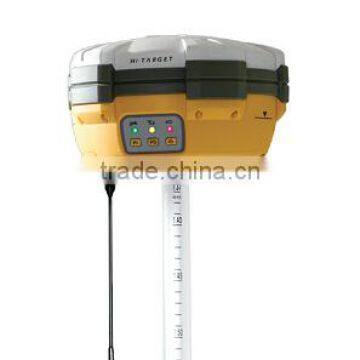
Hi-target V30 Rtk Dual Frequency GNSS RTK
US$ 11,000 - 12,000
/ Piece
1 Piece(Min. Order)
- shanghai
- T/T Credit Card

You May Like
Product Details
| Type | Other | Place of Origin | Guangdong, China | |
| Brand Name | Hi-target | Model Number | V30 | |
| Warranty | 1 Years |
Product Description
Specifications
1.Dual-frequency RTK GNSS.2.220-channel GPS+GLONASS+SBAS.
3.Integrated UHF+GSM/GPRS+Bluetooth.
4.Carlson SurvCE-software.
| HI-TARGET V30 | |
| 220 Channels | |
| Advanced Pacific Crest Maxwell 6 Custom Survey GNSS Technology | |
| High precision multiple correlator for GNSS pseudo range measurements | |
| Unfiltered, unsmoothed pseudo range measurements data for low noise, low multipath error, low time domain correlation | |
| Very low noise GNSS carrier phase measurements with <1 mm precision in a 1 Hz bandwidth | |
| Signal-to-Noise ratios reported in dB-Hz | |
| Proven Pacific Crest low elevation tracking technology | |
| Satellite signals tracked simultaneously | |
| GPS: Simultaneous L1C/A, L2C, L2E, L5 | |
| GLONASS: Simultaneous L1C/A, L1P | |
| L2C/A (GLONASS M only), L2P | |
| SBAS: Simultaneous L1 C/A, L5 | |
| Galileo: Simultaneous L1 BOC, E5A, E5B, E5AltBOC | |
| BDS/Compass(optional): B1, B2 | |
| QZSS: L1 C/A, L1 SAIF, L2C, L5 | |
| Static and Fast Static GNSS surveying | |
| Horizontal: 2.5mm+0.5ppm RMS | |
| Vertical: 5mm+0.5ppm RMS | |
| Post Processing Kinematic (PPK / Stop & Go) GNSS surveying | |
| Horizontal: 1cm+1ppm RMS | |
| Vertical: 2.5cm+1ppm RMS | |
| Initialization time: typically 10 minutes for base while | |
| 5 minutes for rover | |
| Initialization reliability: typically > 99.9% | |
| RealtimeKinematic(RTK) surveying | |
| Horizontal: 8mm+1ppm RMS | |
| Vertical: 15mm+1ppm RMS | |
| Initialization time: typically < 8 seconds | |
| Initialization reliability: typically > 99.9% | |
| Code Differential GNSS positioning | |
| Horizontal: 25cm+1ppm RMS | |
| Vertical: 50cm+1ppm RMS | |
| SBAS[iv]: 0.50m Horizontal, 0.85m Vertical | |
| Physical | |
| Dimensions (W x H): 19.50cm x 10.40cm(7.68 in x 4.09 in) | |
| Weight: 1.3kg (2.86lb) with internal battery, internal radio, | |
| standard UHF antenna | |
| Operating temperature: -45℃to +65℃ | |
| Storage temperature: -55℃ to +85℃ | |
| Humidity: 100%, considering | |
| Water/dustproof: IP67 dustproof, protected from temporary immersion to depth of 1m (3.28ft) | |
| Shock and Vibration: Designed to survive a 3m(9.84ft) natural fall onto concrete | |
| Electrical | |
| Power 6V to 28V DC external power input | |
| Power consumption 2.5W | |
| Automatic Switching between internal power and external power | |
| Rechargeable, removable 7.4V, 4400mAh Lithium-Ion battery | |
| in internal battery compartment | |
| Static 13 - 15 hours | |
| RTK Rover (UHF/GPRS/3G) 10 - 12 hours | |
| RTK Base 8 - 10 hours | |
| I/O interface | |
| 1 x Bluetooth | |
| 1 x standard USB2.0 port | |
| 2 x RS232 serial port | |
| 2 x DC power input (8-pin & 5-pin) | |
| Field Software | |
| There are optional field controllers and software in the V30 package. The controllers with OS Microsoft Windows Mobile 6.5 are fully compatible with the third party software such as Carlson SurvCE,MicroSurveyFieldGenius, Digiterra Explorer, EsriArcPad etc. besides standard field&GIS software made by HITARGET. HITARGET controller with WiFi, Bluetooth, and GPRS/3G is completely wireless to connect to any device, collect data andconnect to server simultaneously and seamlessly. | |
| Post-processing Software | |
| HI-TARGETGeomatics Office (HGO) software natural fall onto concrete suite of programs to support HI-TARGET GNSS receivers. Standard Rinex data and HI-TARGET raw data can be processed flexibly and easily. | |
| GPRS/GSM or 3G | |
| Fully integrated, fully sealed internal GPRS/GSM or 3G | |
| Network RTK (via CORS) range20-50km | |
| HI-TARGET internal UHF radio (standard) | |
| Frequency: 460 MHz with 116 channels | |
| Transmitting Power: 0.1W, 1W, 2W adjustable | |
| Transmitting Speed: Up to 19.2Kbps | |
| Working Range: 3~5Km typical, 8~10km optimal | |
| HI-TARGET External UHF radio (standard) | |
| Frequency: 460 MHz with 116 channels | |
| Transmitting Power: 5W, 10W, 20W, 30W adjustable | |
| Transmitting Speed: Up to 19.2Kbps | |
| Working Range: 8~10Km typical, 15~20km optimal | |
| Data storage | 64MB internal memory |
| Data formats | |
| (1Hz positioning output, up to 50 Hz - depends on installed option) CMR: sCMRx, CMR, CMR+input and output | |
| RTCM: RTCM 2.1, 2.2, 2.3, 3.0, 3.1 input and output | |
| Navigation outputs ASCII: NMEA-0183 GSV, AVR, RMC, HDT, VGK, VHD, ROT, GGK, GGA, GSA, ZDA, VTG, GST, PJT, PJK, BPQ, GLL, GRS, GBS | |
| Navigation outputs Binary: GSOF | |
| 1 Pulse Per Second Output | |
Cloud Chen
Sales & Marketing Dept.
Shanghai Sursup Precision Instrument Co., LTD
addr: Building 67, Lane 258, West Xiuyan Road, Pudong New District, Shanghai, China
Tel: +86-21-50594134-8005 Fax: +86-21-20227879
Mobil&Whatsapp: +86-13817904831;
Skype:sursup_sales5
Web site:
Contact Us

- Shanghai Sursup Precision Instrument Co., Ltd.
- Contact nameCloud Chen Chat Now
- Phone86-21-50594134
- AddressBuilding 8-2, 128 Sanlin Rd.
Product Categories
| Auto Level | Batteries | data cable | Laser Products |
| Leveling Staff | New Products | Others | Poles |
| Prism | RTK | Theodolite | Total Station |
| Tripod |
New Products
-
TJOP Theodolite
-
FOIF Electronic Theodolite DT202C
-
FOIF Electronic Theodolite DT205D
-
FOIF Electronic Theodolite DT302
-
DADI DE2A Theodolite
-
DADI DE2B Theodolite
-
Laisai LS3402J Theodolite
-
SETL SDJ02 Theodolite
-
SETL SJDJ02 Theodolite
-
THEODOLITE DADI DE2A,digital Theodolite,surveying,optical Instrument,surveying
-
Hot Sell TJOP Theodolite Nice Price
-
Best Price TJOP Theodolite Surveying Instrument
Popular Searches
- satellite
- gsm
- gps navigator
- gps navigation box
- gps chipset
- car gps
- box gps car navigation
- vehicle device
- gps tracker
- car tracker
- gps car alarm
- tracking car alarm
- gps navigation
- car navigation
- gps navigation system
- car gps tracker
- gps tracking system
- gps vehicle tracking system
- gps map
- mini antenna satellite
- sim card backup
- car gps navigation
- gps system
- navigator
- gps device
- portable gps
- car navigation gps
- tracker gps
- gps tracking
- marine gps
Recommended Products
- GPS for Children and Elderly, 4G Locator for Children and Babies, Anti Turning Remote Tracking for the Elderly, Anti Loss Pendant, Anti Loss Device
- 4G Wireless GPS Locator, Car Anti-theft Pickup Positioning, Remote Tracking Tracker, Car Mounted Beidou Anti Loss Device
- Original SMC IP200-120 Cylinder Positioner New Original Authentic
- Hi Target GPS V200 GNSS RTK Receiver With Tilt Sensor
- Hi Target GPS V200 GNSS RTK Receiver With Tilt Sensor
- 4 Channel HD Mobile DVR 1080P Public Bus Truck Mdvr GPS 3G 4G Mobile DVR
- Full HD HDD 8CH 1080P DVR Para Vigilancia Por Vídeo de Seguran?a de Veículos
- 107M Series (Type A, Type B, Type C, Type D) Double Antenna Combination Micro Inertial Measurement System
- 105M Series (Type A, Type B, Type C, Type D) Single Antenna Combination Micro Inertial Measurement System
- INS1200 Series Fiber Optic GNSS/INS Integrated Inertial Navigation System of Type A, Type B, Type C, and Type D
- INS900 Series Fiber Optic GNSS/INS Integrated Inertial Navigation System of Type A, Type B, Type C, and Type D
- INS600 Series Fiber Optic GNSS/INS Integrated Inertial Navigation System of Type A, Type B, Type C, and Type D
Find Similar Products By Category
- Electrical & Electronics > GPS > GPS Navigator
- Please Enter your Email Address
- Please enter the content for your inquiry.
We will find the most reliable suppliers for you according to your description.
Send Now
Shanghai Sursup Precision Instrument Co., Ltd.
AIBot OnlineThis conversation is AI-generated. Contact manufacturer before transaction to confirm info.
-
 Cloud Chen
Hi there! Welcome to my shop. Let me know if you have any questions.
Cloud Chen
Hi there! Welcome to my shop. Let me know if you have any questions.
Your message has exceeded the limit.
- Contact supplier for lowest price
- Customized Request
- Request Sample
- Request Free Catalogs
Your message has exceeded the limit.
-
Purchase Quantity
-
*Sourcing Details
Your inquiry content must be between 10 to 5000 characters.
-
*Email
Please enter Your valid email address.
-
Mobile